
Pic. 1. St. Michael's Mount, Penwith, Cornwall
The St. Michael/Mary alignment is probably the best known of
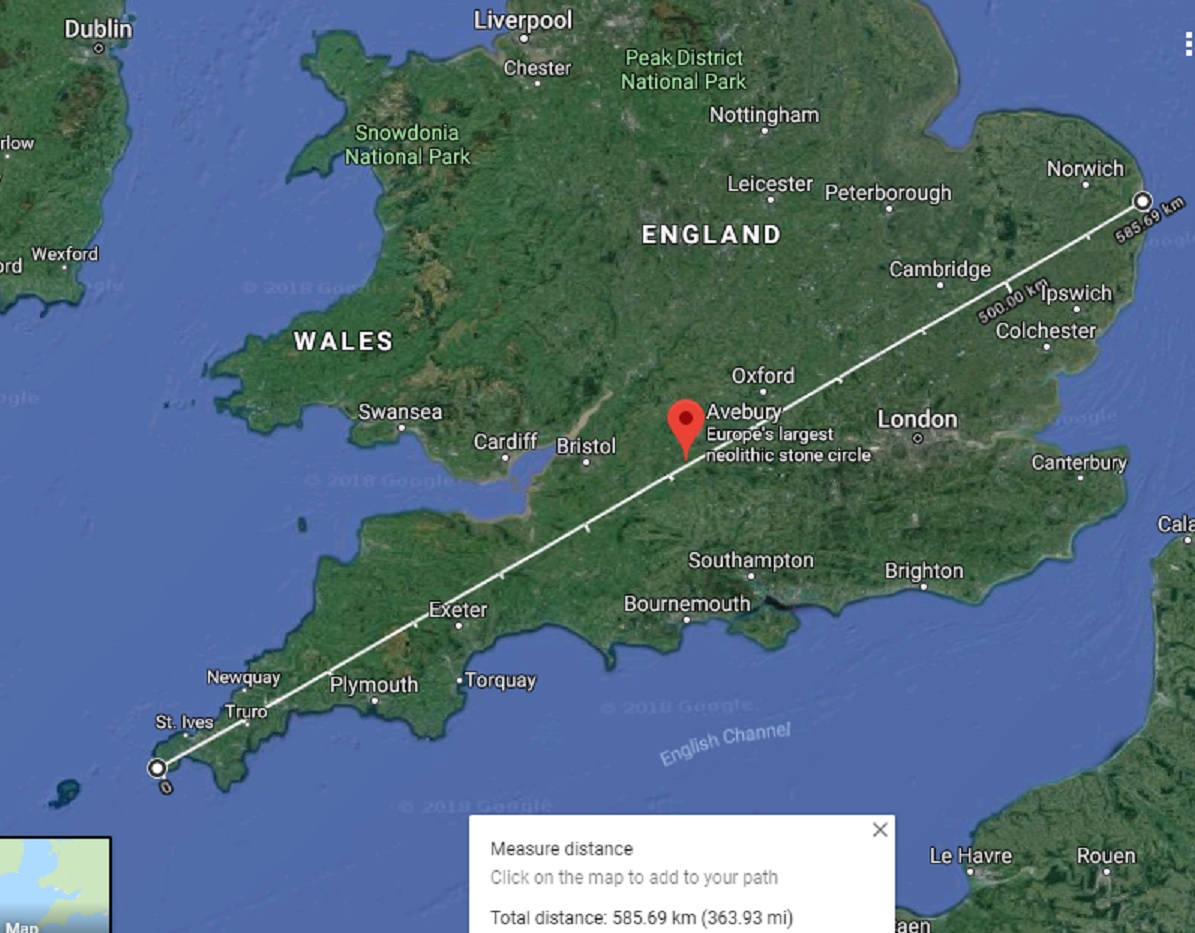
all alignments of ancient sites. From shore to shore it stretches around 364
miles (585.80 km) from the dramatic clifftop promontory fort site on Carn Lês Boel, near Land's End in south-west Cornwall to the
beach at Hopton, Norfolk, on the East Anglian coast. It passes through or next
to many sites including: St. Michaels Mount,
- Carn Brea Neolithic tor enclosure, - the Hurlers stone circles, -
Burrow Mump, - Glastonbury Tor, -
Roundway Downs Castle, - Avebury Henge, etc.
It is traditionally said to be at around 63 degrees from SW
to NE, in the direction of the Beltane sunrise. This orientation is said to be
the sunrise on the 8th of May which is a day on which the apparition
of St. Michael is celebrated in Latin Christianity. Also the alignment passes
next to many churches, many of them dedicated to St. Michael & St. George,
both dragon slaying, sun deity saints, & to St. Mary.
Some sites on the alignment such as Burrow Mump, Roundway Castle etc. that are not included in this study are examined in another post; "The St. Michael triangle & the Mont St. Michel - Stonehenge - Avebury alignment" (https://ancientwhisperspenwith.blogspot.com/2019/02/the-st-michael-triangle-duke-line.html).
Some sites on the alignment such as Burrow Mump, Roundway Castle etc. that are not included in this study are examined in another post; "The St. Michael triangle & the Mont St. Michel - Stonehenge - Avebury alignment" (https://ancientwhisperspenwith.blogspot.com/2019/02/the-st-michael-triangle-duke-line.html).
The general orientation of the northern quarter
days (Beltane & Lughnasadh) rise is 65 degrees. NE, the geometric direction
of the full moon rise limit closest to the equinox in the north is 60 degrees.
The St. Mich./Mary alignment is
traditionally placed in between these at 63 deg. NE but through my research I
have realised that the orientation changes gradually as you move along the alignment. The Mich/Mary line gains approx. 1 degree as you travel up it but different orientations will have different rates of gain.With an on-screen protractor the alignment is exactly 60 deg. in between the top two stone circles of The Hurlers stone circles in Bodmin Moor, Cornwall (mentioned later in this post).
Diag.1. Geometric/General Solar/Lunar rise/set orientations
Diag.1. Geometric/General Solar/Lunar rise/set orientations

My methods of tracking alignments is simple, I use internet
map & satellite facilities, using the mouse left hand click “measure
distance” facility. This draws a line between chosen spots - a line that very handily allows for the curvature of the Earth. If you get a bit
creative with it you can depict multiple lines crossing, this of course renders
the distance measurements irrelevant as you have to go up & down the lines
to perform this. The distance measurements on the screen are only relevant when
an entire single line is shown.
The picture below is a satellite image of the St. Michael/Mary
line in it’s UK mainland entirety, with Avebury Henge & stone circles at it's center. It's orientation is a general 60 deg. NE.
In this
post, as we explore different sites on this alignment we will be zooming in on
certain places on this line. Remember that this is all one same line, nothing
is re-drawn for each satellite image we are simply zooming in on the same picture.
Sat. Image 1. Avebury, the centre of the Michael/Mary alignment.

Avebury Henge & stone circles mark the centre spot of
the St. Mich./Mary line from coast to coast. In my previous posts I have
explored some geometry contained within the dimensions of Avebury Henge, including
isolating a “practical centre” to the ancient mechanism, so as there is now a precise
central point identified, that we already know other alignments pass through,
we can put our first point on this spot which, as we learned in my first post
“Avebury Geometry Pt. 1” (https://ancientwhisperspenwith.blogspot.com/2018/11/avebury-geometry.html), lies equidistant between the central features of the
inner circles, the Cove (partially still standing) & the Obelisk
(destroyed, now marked with a concrete post).
Plan 1. Avebury Henge crossed edge alignments marking the practical centre


Plan 1. Avebury Henge crossed edge alignments marking the practical centre


Sat. image 2, the practical centre of Avebury Henge, equidistant between the Cove & the Obelisk marker
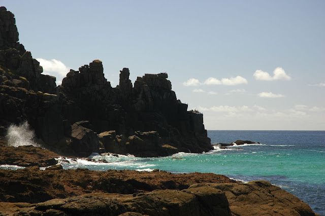
Then we locate the beautiful promontory of Carn Lês Boel (pron. Karn Leez BOEL) at the SW extremity of west Cornwall, just round the corner from Lands
End. At Carn Lês Boel there is an Iron-Age fort site with a small ditch &
bank surrounding. Along it's length there remain a few blocks of stone where once stood
a wall. There are also some older features such as menhirs & barrows.
As you approach the headland you will pass between two
menhirs, one standing, one recumbent.
They are not marked on the Ordinance Survey maps etc. but it is plain to see
small flat stones placed underneath for support. Between these two stones is where we put our second
spot, understanding of course that the line continues on into the sea. Now we
have half of the line.


Sat. Image 3. Mich./Mary line, - Carn Lês Boel, Penwith, south-west Cornwall

Pic.3, Carn Lês Boel promontory Penwith, Cornwall

Pic. 4. Standing stones (one recumbent) at Carn Lês Boel looking seaward
To extrapolate & achieve the rest of the line, type "Hopton" into the search to be taken to that town on the East Anglian coast which is the NE extreme of the alignment . By trial & error placing & by switching from Hopton to Avebury & back, try to find the placement in Hopton that unifies the lines all the way to the west Cornwall tip and has the line passing through the "practical centre" at Avebury.


Sat. image 4, Hopton, the north-east extreme of the Michael/Mary line
Now we have a full line, we can focus on certain ancient
sites & natural features along it. The subject of natural features appearing
on alignments is a tricky one as many people think that only mankind can place
things in a straight line. From studying many alignments I have to abandon this
line of thought & accept that there are many things we don’t yet understand
as coincidence can’t explain how many dramatic hills, tors, pools, major river mouths, islands etc. appear on these lines. Sites like St. Michaels Mount,
Glastonbury Tor, Burrow Mump etc. are all naturally occurring features.
Our starting place is Carn Lês Boel promontory fort in
Penwith, Cornwall, close to Lands’ End. A spot I know well.
The name Carn Lês Boel means “ the rocky outcrop of (with) the
hatchet court” – “court “ probably referring to the remains of an Iron-age
hillfort & hatchet referring to the next headland along called “Carn Boel”
(the rocky outcrop with the hatchet) which has a rock formation at the end that
looks remarkably like a hatchet.
From climbing around on the end of Carn Lês Boel promontory
(extreme caution is advised!) I have seen the ends of huge quartz veins,
explaining its’ physical endurance. The general geological structure seems to run at a similar orientation to the alignment (see sat. image below).
Coming from the sea, it runs between two menhirs, then heads for an ancient barrow close to the fort but not marked on ordinance survey maps.

It continues inland towards Alsia (pron.
AY-lee-ah) Mill & holywell, running alongside it.
Alsia well, like most holywells, was used in history for healing & divination purposes – reputedly useful for healing rickety children & foretelling the likelihood of marriage from a potential partner.


Sat. image 5, between the menhirs at Carn Lês Boel
Map 1, Michael/Mary line running from between two menhirs & through Bosistow barrow/tumulus at Carn Lês Boel
Alsia well, like most holywells, was used in history for healing & divination purposes – reputedly useful for healing rickety children & foretelling the likelihood of marriage from a potential partner.

Sat. Image 6,- Michael/Mary line, - Alsia Holy Well
It passes many ancient sites overland including Tresvennack menhir & runs past Faugan Round & standing stones before running through Newlyn & entering Mounts Bay at the root of Newlyn pier. It then continues in front of Penzance
seafront promenade, passing very close to the headland (behind Jubilee Swimming Pool) that
gave Penzance its’ name which translates as “the holy headland” (pen = head or
end, sans = sacred or sainted). Before Penzance existed this was a rocky headland
between Marazion (pron. mara-ZION) & Mousehole (pron. MOU-zel) useful as a natural jetty for the local hardy
fishermen. This use would have probably been exploited through the ages.
Like many headlands & rocky islands then, it had a small chapel, this one dedicated to St. Anthony – the patron Saint of fishermen.

By local standards the Holy Headland is a bit of a stubby one but it can be seen in the satellite images that before the inundation of Mounts Bay it could have stretched 600 meters all the way to a now all but submerged rock called Gear Rock or The Gear which comes from the Cornish "caer" (pron. a bit like "care" but with a slight y sound in the middle) meaning fortress. This rock has been identified as a possible source of greenstone for making axes in the Neolithic. Today it is marked with flashing beacon pole.
Like many headlands & rocky islands then, it had a small chapel, this one dedicated to St. Anthony – the patron Saint of fishermen.

Sat. Image 7, Mich./Mary line, - Newlyn, Penzance & St. Michaels Mount, Mounts Bay
By local standards the Holy Headland is a bit of a stubby one but it can be seen in the satellite images that before the inundation of Mounts Bay it could have stretched 600 meters all the way to a now all but submerged rock called Gear Rock or The Gear which comes from the Cornish "caer" (pron. a bit like "care" but with a slight y sound in the middle) meaning fortress. This rock has been identified as a possible source of greenstone for making axes in the Neolithic. Today it is marked with flashing beacon pole.

Pic.5, Gear Rock or The Gear off
the Holy Headland, Penzance

Sat. Image 8, The Gear & the St. Michael/Mary line at the Holy Headland, Penzance
The line then runs through a long reef off the coast of Longrock which gives the village it's name. this is the spot where the Michael/Mary line crosses the Apollo/ Athena line (see other post; (https://ancientwhisperspenwith.blogspot.com/2019/02/the-st-michael-triangle-duke-line.html )
It then runs as close as it gets to St. Michael's Mount (about 1.40 km, 4,578 Ft.)
As with many named sites along the line,The Michael/Mary alignment does not actually pass through St. Michael's Mount (the Apollo/Athena line does) but passes closer to it than it does St. Michael's Tower on the summit of Glastonbury Tor (1.81 km, 1.13 Mls.) for example.

Pic. 6. St. Michaels Mount, Penwith, Cornwall
St Michael's Mount is one of the most dramatic of the dramatic natural features along the alignment offering a stunning spectacle due to it being surrounded by sea. This was probably not always the case as it's old Cornish name "Carreg Los yn Cos (trans. the big grey rock in the woods) would suggest.
Yes west Cornwall holds to a legend of an ancient land spreading from around Lands End & Mounts Bay to the Isles of Scilly called the Lyonesse that was inundated due to a great storm with few of the land's inhabitants surviving. The old local stories have the reef off Lands End (named The Seven Stones) as the site of "The City of Lions" which gave the land it's name. Lyonesse was not only said to have been very beautiful but also a very holy land, tales reporting over 40 churches or holy places between Lands End & the Scilly Isles. Local fishermen have claimed to have heard their bells ringing during storms.When the inundation took place is generally thought to have been in the bronze-age although references to Lyonesse can be found in Arthurian legend & the folk tales suggest a time during the early Christian era.
Just like it's French namesake Le Mont Saint Michel (see following post on the St. Michael Triangle: https://ancientwhisperspenwith.blogspot.com/2019/02/the-st-michael-triangle-duke-line.html) The Mount developed it's name & devotion to Saint Michael after sightings of an apparition of the Saint made it an early place of pilgrimage
Whether surrounded by sea or land the Mount would have been a beautiful & useful place to anyone who came across it since prehistory. Archaeological evidence has been unearthed on the spot to suggest this is so including a neolithic (new stone-age - circa 4000 - 2500 B.C.) leaf shaped flint arrowhead & even flints thought to have been from the mesolithic (middle stone-age - 9000 - 6000 B.C.)
The site has been developed from usage throughout history being the site of first a monastery in the late 8th - 11th centuries. Edward the Confessor presented the Mount to the Norman Abbey of Le Mont Sant Michel until it was taken back during Henry V's war with France. It was also a place of pilgrimage encouraged by Pope Gregory during the 11th century.
After the Mount the line heads "up-country", passes close to the town of Camborne before heading for the dramatic peaks of the neolithic tor enclosure that is Carn Brea (trans. (from the Cornish) - the hill with the rock pile). This is where we find our first significant "coincidence event"!

Pic. 7, Carn Brea neolithic tor enclosure with the Basset Monument & castle/folly


Carn Brea was the first neolithic "tor enclosure" to be identified although other such sites have been found since such as Carn Galver & Trencrom Hill, both in Penwith, Cornwall. It shows signs of human activity from 3900 BC. & the style of enclosure has been compared to the causewayed camps of, for instance, sites in Wiltshire such as Windmill Hill near Avebury.

Sat. image 9, Michael/Mary line at Carn Brea, between the towns of Camborne & Redruth, Cornwall.
As we can see from the satellite images above & below, the Michael/Mary alignment not only passes through the length of the entire hill but also (seen more clearly on the closer image below) hits both peaks or carns, surmounted by the Basset Monument & Carn Brea Castle which was built in the fourteenth century (being extensively remodeled in the 18th century) as a hunting lodge/ folly.
Of course the hill & carns are natural features so could not have been positioned intently but it can not be denied that the whole feature is orientated along the alignment. This again suggests the possibility that the feature may be the result of ancient seismic or volcanic activity along a possible fault line which connects the sites of the alignment.
"Coincidence" again that Carn Brea is a solitary hill, it stands alone yet marks the spot where the alignment passes & displays it's orientation - all by completely natural means.
"Coincidence" again that Carn Brea is a solitary hill, it stands alone yet marks the spot where the alignment passes & displays it's orientation - all by completely natural means.

Sat. image 10, Michael/Mary line hitting both peaks of Carn Brea

Pic. 8, Carn Brea Castle/Folly with St. Agnes Beacon in the distance

 Sat. image 11, Michael/Mary line passing between the upper two circles of the Hurlers

Yes, as can be seen in the satellite image above, the precise placement of the Tintagel-Jersey line has it passing through the same circles at the Hurlers, again forming an edge alignment with the upper.

The Tintagel-Bodmin Moor-Jersey alignment
Let's now look at some of the features along the Tintagel-Jersey line:

 Sat. image 14, The Tintagel-Jersey line at Tintagel Head
The line comes out of the sea at Tintagel Head running through the centre of the neck connecting it to the mainland. it is from just over 310 degrees (N-W) and runs to just over 120 degrees (S-E) so runs from the direction of the midsummer solstice sunset to the midwinter solstice sunrise. This is not a direction of energy flow or anything, just the direction I have chose to start from.
The alignment not only runs through the Castle complex but runs along the wall of the mainland castle which, as can be seen in the closer satellite image below, seems to have been built on the same orientation, this could definitely be considered a "coincidence" event!.
coincidence or not, this wall physically displays the direction of this major alignment & has an edge alignment with the top circle of the Hurlers etc.

 Sat. image 16, Tint.-Jersey line crossing Rough Tor & Brown Willy, Bodmin Moor


 Sat. image 19, Tintagel-Jersey line crossing Michael/Mary line at The Hurlers & Caradon Hill
Caradon Hill near The Hurlers stone circles is also a site of much ancient activity & is pretty much covered in cairns as shown in the map below.The Tintagel-Jersey line crosses it near the summit, as can be seen by the satellite image above.
 Map 3. Caradon Hill, a site with many ancient cairns & earthworks
The satellite image below is provided for an example of many ridges & ancient earthworks that the line crosses, with this earthwork near the summit of a ridge on Hammett Downs near Quethiok, about 10 miles (16.09 km) further down the line. A map is provided below it for reference.


 Sat. image 21, Tintagel-Jersey line at Plymouth Sound, the mouth of many rivers

...But not just some random area of Jersey, in fact it lands squarely at Le Dolmen Du Couperon - another neolithic-chalcolithic (copper-age) monument (see satellite image below).
 Sat. image 23, Tintagel-Jersey line, Le Dolmen Du Couperon, Jersey


The alignment passes through or near many reputed places but for our next "coincidence" event we'll shoot 50 miles (80.46 km) up the line to The Hurlers stone circles near Minions on the eastern side of Bodmin Moor in Cornwall.
The Hurlers are a set of three late neolithic - early bronze age stone circles, one larger irregular circle in the middle with two slightly smaller & more regular circles above & below, few stones remain in the lowest circle. They are set at a 10 degree (east of north) angle with the axis aligning top & bottom circles (more on this later).

Pic. 9, The Hurlers stone circles, Minions, Cornwall
 Sat. image 11, Michael/Mary line passing between the upper two circles of the Hurlers
Our "coincidence" event here, as displayed on the satellite image above, is that the Michael/Mary alignment passes neatly between the upper two circles, in fact forming an edge alignment with the upper circle.
The circles mark a place where many alignments cross but another major alignment crosses the Michael/Mary line again between the top two circles, as shown on the satellite image below.
This is an alignment that starts at Tintagel Head, the site of an dramatically placed ancient castle reputed in legend to have been the birthplace of King Arthur, then runs across Bodmin Moor hitting Rough Tor, Brown Willy - the highest point of Cornwall, the Hurlers stone circles, Caradon Hill, Plymouth Sound - the mouth of the rivers; Tamar, Plym, Tavy, Lynher & Yealm (many alignments pass through major river mouths, see other posts;https://ancientwhisperspenwith.blogspot.com/2019/02/the-st-michael-triangle-duke-line.html & https://ancientwhisperspenwith.blogspot.com/2019/03/the-carn-les-boel-seahenge-drombeg.html). Then if you follow the line across the sea it lands neatly on Le Dolmen Du Couperon in Jersey.

Sat. image 12, the Tintagel-Jersey & Michael/Mary lines crossing at The Hurlers circles
 Pic.10, The Hurlers near Minions, Bodmin Moor, Cornwall
 Sat. image 13, the Tintagel-Jersey & Michael/Mary lines crossing (edge alignments) between Hurlers circles


Yes, as can be seen in the satellite image above, the precise placement of the Tintagel-Jersey line has it passing through the same circles at the Hurlers, again forming an edge alignment with the upper.
The dowser Hamish Miller famously dowsed the St. Michael & St. Mary energy lines from coast to coast, leaving gaps but covering most of the alignment. in the resulting book, "The Sun & The Serpent" he records dowsing the St. Michael & Mary energy lines in February 1989. He detected the St. Mary energy line passing through the very centre of the structure at a perpendicular (right-angle cross) angle to the axis line.
He had the St Michael energy line entering the bottom circle along the axis, continuing up the axis crossing the St. Mary energy line where both lines briefly diminish to a node point, continuing up the axis until it reaches the upper circle where it suddenly veers eastward at the very point our alignments cross then goes around the edge of the circle until it continues north-east (see plan below). Here we see an energy line perhaps being affected by a major alignments cross.

Plan 2, Michael & Mary energy lines at the Hurlers as dowsed by Hamish Miller in Feb. 1989, with crossed alignments
The Tintagel-Bodmin Moor-Jersey alignment
Let's now look at some of the features along the Tintagel-Jersey line:

Pic. 11, Tintagel Head & Castle with mainland castle wall in foreground

The line comes out of the sea at Tintagel Head running through the centre of the neck connecting it to the mainland. it is from just over 310 degrees (N-W) and runs to just over 120 degrees (S-E) so runs from the direction of the midsummer solstice sunset to the midwinter solstice sunrise. This is not a direction of energy flow or anything, just the direction I have chose to start from.
The alignment not only runs through the Castle complex but runs along the wall of the mainland castle which, as can be seen in the closer satellite image below, seems to have been built on the same orientation, this could definitely be considered a "coincidence" event!.
coincidence or not, this wall physically displays the direction of this major alignment & has an edge alignment with the top circle of the Hurlers etc.

Sat. image 15, Tintagel-Jersey line running in the same direction along the mainland castle wall at Tintagel
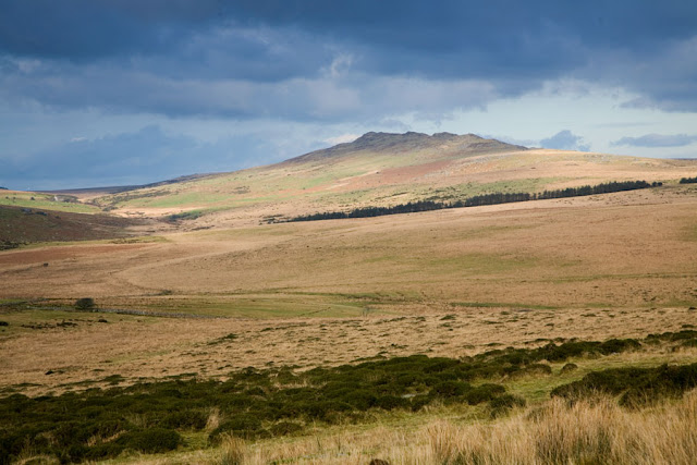
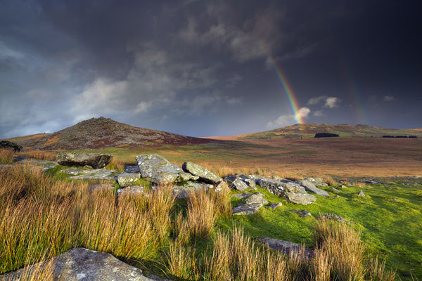
The line then runs across Bodmin Moor, crossing both Rough Tor (locally pron. Rowter) & Brown Willy ( Cornish; Bron = Hill, Wennili = swallows), the highest point of Cornwall.
Both hills are iconic features on Bodmin Moor & as can be seen on the map below, both were locations of much ancient activity. The stone circle in the extreme south-west of the map below, near Louden Hill is Stannon Stone Circle (more later - future posts).
I have spent much time on Bodmin Moor & the sunset silhouetted view of the sweeping peaks of Brown Willy on the horizon is a familiar, reassuring & very mystical sight.
 Sat. image 16, Tint.-Jersey line crossing Rough Tor & Brown Willy, Bodmin Moor
The satellite image above suggests that the alignment runs across the most female part of Rough Tor & the most male part of Brown Willy. In fact Rough Tor has a cupped appearance like a cove (or yoni) & Brown Willy is obelisk (or lingham) shaped. They are also equidistant from the De Lank river.

Map 1, Rough Tor & Brown Willy, Bodmin Moor, Cornwall
(click on map to enlarge)

Pic. 12, Rough Tor, Bodmin Moor, Cornwall

Pic. 13, Brown Willy, highest point of Cornwall, Bodmin Moor

Pic. 14., horses by rock formations or "carns", Rough Tor
Pic. 15., Rough Tor & Brown Willy, Bodmin Moor
After passing many ancient features across Bodmin Moor such as the Medieval Village of Tresibbet & Goodaver Stone Circle both at Trezibbet near Dozmary Pool, a pool connected with King Arthur as the last resting place of his sword Excalibur.
Of course the King of the land's sword entering the lake of the lady has harmonious union connotations.

Pic. 16, Goodaver Stone Circle near Dozmary Pool, Bodmin Moor

Sat. image 17, Tintagel - Jersey line at the Medieval Village of Tresibbet, Goodaver Stone Circle & Dozmary Pool
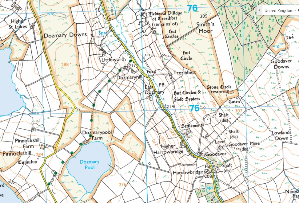
Map 2, Medieval Village of Tresibbet (remains) & Goodaver Stone Circle near Dozmary Pool
The alignment then runs through & crosses the Michael/Mary alignment at the Hurlers Stone Circles:

Sat. image 18, Tintagel-Jersey line crossing the Michael/Mary line at the Hurlers Stone Circles
The plan below shows that the Hurlers 10 degree axis provides a placement for a hexagram to pick up the Tintagel-Jersey line & also makes some geometric sense of the placement & shape of the ovoid middle circle.
The 10 degree tilted hexagram is already familiar to us of course from the 2nd. post on this blog; "Windmill & Silbury Hill alignments & the crop circle hexagram "(https://ancientwhisperspenwith.blogspot.com/2018/11/avebury-geometry-pt-2-a.html) in which we find a hexagram at that same angle decoding much information from Avebury Henge, a site 130 miles (209.21 km) up the same alignment. The plan beneath it is reproduced from that post.

Plan 3, The Hurlers axis providing a 10 deg. tilt to read the Tintagel & Jersey line with a hexagram

Plan 4, Avebury Henge mechanism responding to a hexagram with a 10 deg. eastward tilt provided by Silbury Hill

Caradon Hill near The Hurlers stone circles is also a site of much ancient activity & is pretty much covered in cairns as shown in the map below.The Tintagel-Jersey line crosses it near the summit, as can be seen by the satellite image above.

(click on map to enlarge)
The satellite image below is provided for an example of many ridges & ancient earthworks that the line crosses, with this earthwork near the summit of a ridge on Hammett Downs near Quethiok, about 10 miles (16.09 km) further down the line. A map is provided below it for reference.

Sat. image 20, Tintagel-Jersey line crossing ridge & earthwork at Hammett Down near Quethiok in Cornwall

Map 4, Earthwork at Hammett Down near Quethiok
When the line reaches the sea at Plymouth Sound it manages to cross many river mouths including; the Tamar, Plym, Tavy, Lynher & Yealm (Sat. image below).
Many river mouths or inlets seem to appear along major alignments such as the Avebury - Mont St. Michel line (https://ancientwhisperspenwith.blogspot.com/2019/02/the-st-michael-triangle-duke-line.html) running across the mouths of the rivers Stour & Avon at Christchurch near Bournemouth.
 Sat. image 21, Tintagel-Jersey line at Plymouth Sound, the mouth of many rivers
When we reach the Channel Islands, it can be seen from the satellite image below that the alignment manages to hit Guernsey, clips the southern extreme of Herm, clips the south-western extreme of Brecquou, runs across Sark & then hits the north-east extreme of Jersey, the islands representing again a hardy sediment resulting from volcanic or seismic activity & all linked by the alignment.

Sat. image 22, Tintagel-Jersey line in the Channel Islands
...But not just some random area of Jersey, in fact it lands squarely at Le Dolmen Du Couperon - another neolithic-chalcolithic (copper-age) monument (see satellite image below).


Pics. 17 & 18. Le Dolmen Du Couperon neolithic-chalcolithic dolmen, Jersey


 Pic 21. Avebury Henge


Back to the Michael/Mary line
So lets continue up the Michael/Mary line from The Hurlers.
Just 8.73 miles (14 km) up the line the Tamar river performs a spetacular bow around a promontory. The alignment not only runs right across it ( pic below) , but bulls-eyes an earthwork near the summit (map below) also hitting the exact point where the river Inney joins the Tamar.
This landscape again suggests sedimentary anomalies from volcanic/seismic action, causing the river to meander & so also causing the promontory.

Sat. image 24, The Mich./Mary line, Duntrue Woods near Dunterton

Map 5, Earthwork at Duntrue Woods near Dunterton
There are so many interesting & beautiful places along the alignment with many a "coincidence" event so, of course, such as Burrow Mump, another sudden mound site, I could not possibly have the time to go in to all of them so we are going to zip 79.6 miles (128 km) all the way to a very well known site on the line.

Pic. 19, Glastonbury Tor
Glastonbury Tor, like St. Michaels Mount etc., does not lie exactly on the alignment. I would like to say that, just like at Carn Brea, it travels right up it's back ridge & straight through St. Michaels Tower on it's summit, but this is not the case
The Tor lies neatly on top of the alignment, facing the same direction. It is very significant to the Michael/Mary alignment as the dowser Hamish Miller traced both the Michael & Mary energy lines climbing the Tor in a labyrinthine manner forming two interlocking shapes at the summit suggesting a chalice & probe (Cove & Obelisk?) or sexual union.
It is "coincidence" enough that the Tor is aligned in the same direction &, as can be seen in the satellite image below, has a definite relationship.
Again another volcanic/seismic hill facing the same direction, just like Carn Brea.

Sat. image 25, The Mich./Mary line, Glastonbury Tor

Pic. 20, Glastonbury Tor at sunset
Now we will shoot another 41.48 miles (66.76 km) up-line back to our other start point (& slightly beyond) - Avebury Henge.

Although the practical centre of the Avebury mechanism was our starting point, it is no less "coincidence" event as it passes through the spot that was the centre point of all the revelations in posts 1, "Avebury geometry part 1, - finding the practical centre of the Avebury mechanism & the cross-quarter day lozenge"(https://ancientwhisperspenwith.blogspot.com/2018/11/avebury-geometry.html) & 2 "Avebury geometry part 2, - Windmill & Silbury Hill alignments & the crop circle hexagram" (https://ancientwhisperspenwith.blogspot.com/2018/11/avebury-geometry-pt-2-a.html). As we will see, it will also be the centre point of my next post.

Sat. image 26, The Michael/Mary line crossing the practical centre of Avebury (equidistant between the Cove & the Obelisk)
Note in the satellite image above that the position of the 2005 crop circle from post 2 "Avebury Geometry 2..." (https://ancientwhisperspenwith.blogspot.com/2018/11/avebury-geometry-pt-2-a.html) is still marked although no trace of it now remains.
I will not go much past Avebury Henge on this post but will venture another 4.20 miles (6.76 km) up-line, through the Grey Weathers Sarsen Stone fields, where the stones for the construction of the Avebury Stone Circles came from, to a spot on Ogbourne Maisey Downs near Malborough where the alignment passes as close as it gets to Barbury Castle ( 2.10 miles - 3.38 km).
This is our last but one of our "coincidence" event for this post. As can be seen in the satellite image below, the line passes alongside one of three barrows/tumuli, but what can't be seen on this image is that there is an strange, amoebic shaped earthwork enclosing them with "pseudo-pods" reaching up the ridge in the direction of the sun-rise.

Sat. image 27, The Michael/Mary line passing barrows & earthwork on Ogbourne Maisey Downs near Marlborough
Our last "coincidence" event is included just to challenge, or preferably further open the meaning of the word "coincidence" itself. For this we need to zip up-line 62.65 miles (100.83km) to Whipsnade, Dunstable, near London.
As can be seen in the satellite image below, the white lion chalk image in the landscape has it's front paw on the alignment. This lion image was created in 1933 by R.B. Brooke-Greaves to advertise Whipsnade Zoo or Wildlife Park as it was then.
The image does lie on a position at the end of The Ridgeway ancient trackway making it significant. Also landscape images are usually placed on very steep ridges so it can be seen from the ground (except Uffington White Horse, the only really ancient one - over 3000 years old, which can't be clearly seen from anywhere on the ground). Steep hills & ridges again suggest seismic or volcanic activity.
Other landscape images appear on major alignments but are also quite close to ancient features such as the Alton Barnes White Horse on Pewsey Downs (created in 1812), being close to Adams Grave long-barrow, lies on the Avebury - Stonehenge - Mont St. Michel line;(https://ancientwhisperspenwith.blogspot.com/2019/02/the-st-michael-triangle-duke-line.html).

Sat. image 28, the Whipsnade Lion landscape image with front paw on the Michael/Mary alignment
My next post will feature a major "coincidence" event, again concerning the Michael/Mary line & again featuring the practical centre of the Avebury mechanism. (done it - https://ancientwhisperspenwith.blogspot.com/2019/01/the-isles-line-perpendicular-cross-to.html)- It will be a much shorter post!
No comments:
Post a Comment