CLB - Seahenge part 2, the Land's End - The Wash parallel alignment

Pic.1, Dr. Syntax's Head & The Peal, Land's End, Penwith, Cornwall
(CLICK ON ANY IMAGE TO ENLARGE)
In my last post we followed an alignment running from Carn Lês Boel (pron. karn-leez-BOEL) iron-age promontory fort in west Cornwall, U.K. to the site of "Seahenge" bronze-age timber circles at Holme-next-the-Sea, Norfolk; (https://ancientwhisperspenwith.blogspot.com/2019/03/the-carn-les-boel-seahenge-drombeg.html) the line ran from 230 degrees (general/decimal winter solstice sunset) to 50 degrees (gen./dec. summer solstice sunrise) & passed through many ancient sites & churches.
As that line starts from the very same south-west spot as the St. Michael/Mary line (set at near 60 degrees as opposed to the traditional 63 deg.), we can say that it is the decimal/general solstice direction counterpart to the St. Michael/Mary line (set in the direction of the minimum full moon limit).

During the study of this line I discovered that it had a parallel partner alignment running alongside about 1.6 miles (2.6 km) to the north-east also passing through many sites along the way, some of them strangely complimentary to the CLB - Seahenge alignment so, as promised in my last post, this is a part 2 to that study.
The new alignment runs from the headland of Lands End, Penwith (Cornish; pen = end or head, wyth = far) which is the westernmost point of mainland Britain &, like the alignment in the previous study, ends up at The Wash, a large squarish bay & estuary where the counties of Norfolk & Lincolnshire meet on the east coast of the U.K.


Pic.2, Dr. Syntax's Head promontory, Land's End,Cornwall
The headland at Lands End (the westernmost tip of mainland U.K.) is, rather unsympathetically named Dr. Syntax's Head after an early nineteenth century fictitious schoolmaster & Freemason who appeared in stories & cartoon serials at the time. There is a rock on the headland that vaguely resembles the cartoon image (see pic. below).
As one who delights in the romance of the Cornish place-names here in Penwith, I find it a bit of a shame that such an iconic, not to mention dramatically beautiful, headland could not retain it's original Cornish name (probably "Pen (or Pedn) an Wlas" - Cornish; land's end or end of the land) & that the breathtaking impact of the cliffs & crashing turquoise sea were lost in the re-naming.

Pic.3, a vintage postcard of Dr. Syntax's Head, Penwith, Cornwall & the fictitious 19th century schoolmaster character Dr. Syntax (inset)

(Click on image to enlarge)
In the previous two posts; (https://ancientwhisperspenwith.blogspot.com/2019/03/the-carn-les-boel-seahenge-drombeg.html & https://ancientwhisperspenwith.blogspot.com/2019/01/the-st-michaelmary-alignment-my.html) I have alluded to a natural arch called The Song of the Sea at Nanjisal beach which is next to Carn Lês Boel promontory fort. The reason for this was that the arch lies at the end of the CLB - Seahenge alignment (though not central) which is a 230 - 50 degree alignment & seems to be naturally aligned in the same direction. The midwinter sunset shines a beam directly through this arch (see pic. & link below)

Pic.4, The Song of the Sea natural arch, Nanjisal beach near Carn Lês Boel

The fact that a natural arch is at it's most open in the same direction as the alignment that it is on & that the winter solstice sunset shines directly through it would be "coincidence" enough but the fact is that there is another natural arch on the The Peal headland of Lands End that also points in the direction of the parallel alignment. Quite a "coincidence" to have two parallel alignments that each have a natural arch at their south-west terminus that face the same direction & the midwinter sunset shines a beam directly through both those arches.
 Sat. image 4, Lands' End - The Wash alignment, natural arch at The Peal, Land's End & Maen Castle, Penwith, Cornwall


The picture above shows the site of Maen Castle with a natural arch showing on the Land's End promontory in the background. If the picture had been taken a few feet to the left it would face the exact direction of our alignment. This arch remains hidden from the top of the site but as you walk down the slope towards the sea it starts to open. The aperture is at it's longest at the point where our alignment crosses so, "coincidence" or what-ever, this arch marks the direction of the alignment from the perspective of Maen Castle.
Maen Castle is one of the oldest of the many cliff or promontory forts dating back to 4th century BC. it stood at the head of an earlier field system but to date there has been no evidence found of habitation within the rampart & ditch (see picture below). It's name comes from the Cornish word for stone (C.; men, pl.; meyn) but this is probably not for any attribute of the Castle but for the area of it's location which is known as Mayon.
Maen Castle is one of the oldest of the many cliff or promontory forts dating back to 4th century BC. it stood at the head of an earlier field system but to date there has been no evidence found of habitation within the rampart & ditch (see picture below). It's name comes from the Cornish word for stone (C.; men, pl.; meyn) but this is probably not for any attribute of the Castle but for the area of it's location which is known as Mayon.

Pic.6, The rampart, ditch & bank of Maen Castle, Cornwall, U.K.
The Table Maen
A small hamlet & the area in which it lies, Mayon, part of Sennen in S-W Cornwall, owes it's name to a large, flat, natural stone known as the Table Maen, Table Main, Table Mean etc. This historic feature, which lies in the grounds of a private dwelling in the village of Mayon, is said to have been the setting for a victory feast of from three to twelve kings, depending on which version you hear. Some say that it was the setting for a feast for the Saxon king Athelstan on his return from the Isles of Scilly after conquering the whole length of the country but the only historic source for this was the early 16th century writer John Leland who's somewhat overzealous & even fanciful writings were extremely biased in favour of his hero king. The more solid legend with perhaps a suggestion of historic evidence is that it was the site of a celebration of British Celtic kings after the battle of Vellan Druchar.

Pic.7, (taken with kind permission), The Table Maen in a private garden in Mayon, Sennen
The battle of Vellan-Druchar
The legend has it that the "Danes" landed repeatedly at Gwynver beach, Sennen & plundered the dwellings of the nearby settlement of Escalls. On realising the area lay unprotected they pushed further inland & reached Marazion Marshes before heading north to St. Ives Bay.
Warning beacons had been lit before the invaders had set foot on dry land as the weather had prevented them from landing for a few days & when the signal reached Tintagel " King" or "Prince Arthur" gathered nine war hosts & headed south.After three days travelling they engaged with the invaders at a place called Vellan Drucher ( Cornish; vellan = mill, druchier = tucking or fulling) & a bloody battle ensued where all the invading force were slain. So bloody that the mill wheel was said to have turned with the flow of blood.
The defending hosts then made their way to Gwynver beach to dispatch the guards of the boats who were prevented from escape by a local wise-woman's charm.
Then Arthur & the kings consolidated their bond with the waters from St. Senan's Well.After this there was said to have been a great victory feast lain at the Table Maen for the kings of the war hosts where Merlin was said to have appeared and issued a gloomy prophecy;
"The Northmen wild once more shall land,
& leave their bones on Escalls sand,
The soil on Vellan-druchars plain,
Again shall take a sanguine stain,
& o'er the millwheel roll a flood,
Of Danish mixed with Cornish blood,
When thus the vanquished find no tomb,
Expect the dreadful day of doom."
If there is any truth in the tale, the invaders were hardly likely to have been Danes, the Cornish have traditionally referred (especially retrospectively) to all light skinned invaders as "Danes" & dark skinned invaders (such as Spanish Moors etc.) as "Turks" The writer & archaeologist Craig Weatherhill in his book "The Promontory People" (who must be acknowledged for nicely rounding up the above tale) suggests any true event would have occurred in 5th to the 6th century & that they were probably Saxon raiders who came upon the south-west Cornish coast on their way to raids in southern Ireland. A deeper & well researched version of this tale can be found in said book.
The site of Vellan-Druchar still exists to the northeast of St. Buryan & 5 KM (3.11 miles) from Sennen where the ruined Vellan-Druchar cottage was recorded as being a mill in the early 17th century.
The hamlet of Escalls still exists, as can be seen in the map below in the top right hand corner. Our line passes close after it runs across Sennen Cove. Gwynver Beach is just to the east of Escalls Cliff.

Map 1, Land's End, Maen Castle, Sennen & Escalls
(Click on image to enlarge)
The Table Maen itself lies in the hamlet of Mayon which is 600 meters (0.372 miles) away from the alignment which is close but not really on or next to it, but if you look on Mayon Cliff, just to the southwest of Sennen Cove you will see that the line passes close to a tumulus , a cairn & bulls-eyes a well.
The location of St. Senans Well mentioned in the story where the kings obtained the holy water for a blessing is not known. There is a well in the First & Last Inn which is next-door to Sennen Church but it is a drop well & not typical of the local holy-wells, the original well may have been on the same watercourse though.
The well on Mayon Cliff, the one on our alignment, is the only well marked on the Ordinance Survey maps around Sennen & Mayon (plenty of springs though). I have no idea about the age or origin of this well. I have searched for it quite thoroughly but unsuccessfully among the low gorse & brambles until I was finally scared away by an Adder (snake). The well must be quite small & perhaps quite old. The location is a stunning spot for any well, atop Mayon Cliff overlooking Sennen Cove & Land's End.
I will resume the search in winter when the vegetation is lower & the snakes are asleep. An experienced dowser (especially water) would probably do better. If any locals know anything about it please message me.

Pic.8, Tregiffian Vean Chambered Cairn
As shown in the map below, the alignment then passes close to the remains of a neolithic/early bronze age chambered cairn at Tregiffian Vean then a tumulus at the base of Chapel Carn Brea, the last hill on the mainland & very significant with many ancient features, before forming a tight edge alignment at Bartinney Castle.
 Map 2, Land's End, Maen Castle, Tregiffian Vean Chambered Cairn, Carn Brea tumulus & Bartinney Castle
Bartinney Castle was probably never a defensive fort but is in fact a bronze age cairn enclosure with up to eight cairns, some of them ring cairns, enclosed within a low bank of earth & stone. It lies on top of the rounded Bartinney Hill close to Carn Euny settlement with it's Fogou (souterrain or underground passage), Beehive Hut & Holy Wells (satellite image below).
 Sat. image 5 , Lands End - The Wash line at Bartinney Castle
After passing through some hut circles at the bottom of Bartinney Hill, the alignment continues another 2.52 miles (4.06 KM) northeast until we come to Trewern (pron. tre-WERN) Round.
At this point our present alignment crosses another alignment, the Drombeg - Lizard line,featured in the previous post (https://ancientwhisperspenwith.blogspot.com/2019/03/the-carn-les-boel-seahenge-drombeg.html) Both the Land's End - The Wash & the Carn Lês Boel - Seahenge lines cross the Drombeg - Lizard alignment at Cornish Rounds, the former at Trewern Round & the latter at Lesingey (pron; le-ZIN-gey) Round (as shown in the satellite image below).
Both these sites & a piece on Cornish Rounds also feature in the previous post.
 Sat. image 6, Land's End - The Wash & CLB - Seahenge lines crossing the Drombeg - Lizard line at Trewern & Lesingey Rounds

The Carn Lês Boel - Seahenge alignment crosses the Drombeg - Lizard line in the middle of Lesingey Round but the Land's End - The Wash line crosses it to the west of Trewern Round, close to 2 outlying standing stones ("Trewern 2" is no longer there, destroyed in the 1950's)


The alignment continues just 1.39 KM (4.555 ft.) before passing close (780 ft. - 237.7 M) to Madron Holy Well & Ancient Chapel & between them & an outlying menhir (see map below).
The village of Madron is traditionally associated with two saints; St. Maddern, from whom the village takes it's name, & St. Dithy, as in it's older name Landithy (Cornish; lan = holy enclosure [of St.] Dithy) little is known of either saint but the local holy-well predates both.
 Map 3. Line passing Trewern Round & Menhirs, Madron Holy-Well & Ancient Chapel
Weather Madron Well & Ancient Chapel are close enough to be considered "on" this alignment is debatable (they are probably charged with the same energy lines as other sites featured), especially considering the concentration of ancient sites in this area (Penwith), but it's close enough for me to feature this famous example of a holy-well.
Madron Holy-Well
Madron Holy-Well is a pre-christian sacred site that has some renown for healing & divination. One account tells that how in the first half of the 17th century a poor crippled man named John Trelille came to bathe in the waters & then lie on a nearby mound known as St. Maddern's Bed. He performed these tasks three times, the first two times in some agony but after the third time he walked away without his stick."
From time immemorial, as with other local holy-wells, the local young girls have taken pins or bits of straw to drop in the water to foretell who they were likely to marry & how many years until the event. This was traditionally practiced on May Day but later on the closest Sunday.
Today many people still attach ribbon offerings or clooties/clouties (as well as anything else!) to the trees around the well. Although this has always provided an added visual impact to the site, I personally think that it causes littering of plastics etc. as the items invariably end up falling around the site. Perhaps I'm being a bit of a spoilsport but my understanding of the tradition of offering of "clooties" was that you attach a rag to the tree & wish a personal problem or ailment onto that rag, then, as the rag rots away so does your problem. A lot of people today seem to want to leave their mark with non-biodegradable offerings & so making their problems more permanent.
You will be lucky to see the well-head as it is hard to find in a usually submerged area of undergrowth. It is the source of a river that traditionally supplied the whole of nearby Penzance with water.

Madron Chapel & Baptistery
A short distance from the holy-well, & not by accident is Madron Ancient Chapel which is what remains of a 12th. century building which was built on a Celtic predecessor. It retains an alter with a depression (probably a socket for a cross or effigy), bench seating & a remarkable spring fed font or baptistery (see pic. below).
During the civil war the chapel was destroyed by the fanatical Major Ceely of St. Ives although there is said to have been reports of it being roofless before this time.What remains still has great charm & beauty.

 Map 4, Crankan & Chysauster courtyard house settlements
Courtyard Houses
Courtyard Houses are a style of roundhouse found extensively in Penwith dating from the late Iron Age to the Romano-British period, the fashion probably spreading from Europe. They are usually to be found at the head of, usually earlier established, field systems.
They consist of a grouping of separate rooms of different shapes & sizes ensconced within an oval surrounding wall leaving an open courtyard central. They were constructed of stone with thatched, wooden or turf roofs, some had water courses diverted through the courtyards. They are usually built over earlier, more basic roundhouses from as early as the Bronze Age.
 Sat. Image 8, Land's End - The Wash alignment at Chysauster courtyard house settlement


The Iron Age site at Crankan has not been very well preserved with some suggestion that some of the hut circles having been used for more recent cattle enclosures, but, by comparison lots of effort has gone into preserving & maintaining the Chysauster (Cornish; chy = house Sauster = (of) Sylvester) settlement that is because it is in the hands of "English" Heritage, (people of Cornwall rightfully do not consider their land part of England, The Duchy of Cornwall has a unique separate status) this unfortunately means there is an entrance fee.
Chysauster's courtyard houses date from the Romano-British period with the remains of simpler Iron-Age hut circles also found though habitation & field systems in the surrounding area have been found to date from as early as the Bronze Age. The 10 courtyard houses are arranged in a "village" layout & also, like Carn Euny previously mentioned, has a Fogou (pron. FOO-goo) which is the Cornish term for a souterrain or underground passage. Unlike Carn Euny the passage is not open due to structural instability.

 Sat. image 9, Land's End - The Wash (above) & CLB - Seahenge (below) alignments at St. Ives Bay, Godrevy Point & St. Agnes Head
The alignment comes ashore at Penhale Sands near Perranporth where St. Piran (known locally as Perran) was said to have came ashore from Ireland on his millstone.The line passes close to St. Piran's Oratory & Church which it is said he built close to the spot where he came ashore (see satellite image below). At this point the parallel line (CLB - Seahenge) runs along Perran Round.
 Sat. Image 10, The Parallel alignments at Perranporth
In my last post (https://ancientwhisperspenwith.blogspot.com/2019/03/the-carn-les-boel-seahenge-drombeg.html) that follows the parallel, there is a short piece on St. Piran/Perran which I will reproduce below as it is relevant;
Saint Piran (Perran)
St. Piran (Cornish; Perran) was a 6th century abbot saint who, is credited with, amongst other things, rediscovering tin mining in Cornwall. He is one of the three important saints, of many, in the region along with St. Petroc & St. Michael.
He has been identified as the Irish St. Ciarán of Saigir with an adapted pronunciation but there are some arguments against this.
Legend has it that the heathens of Ireland tied him to a millstone & rolled him into a turbulent sea. On contact with his holy person the towering waves were said to have become calm & he floated out to sea on his millstone until he had crossed the Irish Sea & landed on the sands of Perranporth in Cornwall. The millstone may refer to the fact that the Celtic saints used to carry a large, flat stone bowl around their necks used as a portable altar.
The people of Perranporth (along with other Cornish towns) celebrate St. Piran's day with a holiday on & around the 5th of March including parades, story telling, feasts & entertainment.
St. Piran's flag is the recognised banner of Cornwall. It consists of a white cross on a black background & early usage (15th century) includes on the coat of arms of the Saint-Peran family.

St. Piran's Oratory
St. Piran's Oratory was used as a place of worship for centuries. It is probably an early Christian chapel & burial ground. Like Madron Ancient Chapel mentioned earlier, it has a stone bench running round most of the interior, an altar (rebuilt around 1843) & a small nave & chancel.
In the late 1800's it was noticed that the structure was being deformed by surging sand so a protective concrete wall was built around it. During this work a number of skeletons were unearthed including one of a woman with a child in her arms. Also three enigmatic stone heads have been found there, one of a woman.
It is said that the oratory had to be abandoned because local tin streaming had altered the course of the river & flooded the site, - quite an irony for the Saint who was responsible for reintroducing tin production into Cornwall, & so St. Piran's Church was built close by. Others have suggested that both structures were in use for some time.
The eight foot stone cross that stands nearby is one of the oldest in Cornwall, dated as before 960 AD (Charles Henderson) along with the Penzance Market Cross that now stands in Penlee Park, Penzance (before 924 AD - R.A.S. Macalister) & the Doniert Stone (cross fragment) in St. Cleer, on Bodmin Moor which was said to commemorate King Dumgarth who died in 878 AD.


 Sat. Image 12, The Land's End - The Wash alignment at Michaelstow passing three Iron Age sites within 3 miles (4.82 KM)
 Map 5. & Pic.20, Helsbury Castle & Chapel, Michaelstow on the edge of Bodmin Moor
Shortly after, the alignment passes very close (70 M/ 229.6 ft.) to Tresinney Church (St. Adwena) before reaching the point where we cross another alignment featured in a previous post; The Tintagel - Jersey alignment (https://ancientwhisperspenwith.blogspot.com/2019/01/the-st-michaelmary-alignment-my.html).
I would love to say that there was a significant site at this crossing point, as there is for it's parallel partner at the Rough Tor settlement, especially as it forms a perfect 50 degree (general/geometric solstice) cross, but apart from a nearby (450 M/1476.3 ft. away) burial mound (Tumulus) there is little apparent. If you click on the satellite image below to enlarge, it can be seen that the Tintagel - Jersey alignment passes close to a hill-top cairn. also the road leading from Tregoodwell to Rough Tor (Roughtor Road) runs in a very similar direction to the alignment, perhaps an ancient track-way or even a solstice procession.
 sat. Image 13, The Parallel alignments crossing the Tintagel - Jersey line at Bodmin Moor
As the alignment clips the northwest corner of Bodmin Moor it passes close to an ancient cross near Trelay before passing very close (100 M./328.08ft.) to a pair of hilltop burial mounds in Wilsey Down Woods.
Another 9.5 miles (15.29 km) up-line & we pass close to North Tamerton Church (St. Denis) & Holy Well before crossing the river Tamar which is the natural boundary for the Duchy of Cornwall, & so into the county of Devon.
 Map 6, North Tamerton Holy Well & Church near the River Tamar which forms the Cornwall - Devon border
18 miles (28.97 km) into Devon & we pass by Beaford Church (St. George & All Saints) this seems to be all that Devon has to offer for this particular alignment because another 20 miles (32.19 km) we enter Exmoor & the county of Somerset where the line passes close to Brightworthy Barrows hilltop tumuli. Then just 2.5 miles (4.02 km) it hits Hernes Barrow near Withypool. Shortly afterwards (1.18 km/3866.2 ft.) we pass Road Castle Earthwork near Exford. This is a square, hilltop Iron Age fort atop a promontory caused by the River Exe meandering around it.
 Sat. Image 14, Hernes Barrow & Road Castle Earthwork near Exford, Exmoor
Then after passing Wooton Courtenay Church (All Saints) & passing through the town of Minehead, we enter the Bristol Channel & hit one of a pair of small islands; Flat Holm.
 Sat. Image 15, Parallel alignments in the Bristol Channel
In the previous post I explain that when the accompanying alignment (Carn Lês Boel - Seahenge; https://ancientwhisperspenwith.blogspot.com/2019/03/the-carn-les-boel-seahenge-drombeg.html) ran along the island of Steep Holm, I thought to check if there was a parallel alignment that ran against the partnering island of Flat Holm which resulted in this study. For a short piece on Steep Holm please refer to that previous post.
Steep Holm & Flat Holm (Welsh; Ynys Echni) are a continuation of the Mendip Hills with the former lying in England & the latter in Wales. The small islands have been used throughout history, even before they were islands; worked flints have been found on Steep Holm dating from the Neolithic (9000 B.C. - 3000 B.C.) & even from the Mesolithic period (10,000 B.C. - 8000 B.C.) & a neolithic axe has been discovered on Flat Holm when the isles were more than likely hills.

Flat Holm
Flat Holm, like it's partner island Steep Holm has a long history of usage, evidence from the Neolithic era & settlement from the late Neolithic/early Bronze Age has been discovered & also a bronze axe - head. There was Anglo Saxon settlement & evidence that it was , like Steep Holm, used also for a Viking raiding base.
In the 6th century the island was a hermitage home for Saint Cadoc while his friend St. Gildas lived on Steep Holm. The two used to meet up for prayers.
A number of early Christian graves have been discovered there some with skeletons that had been doused with lime indicating a contagious disease as the cause of death


Then, as it passes, our alignment touches the tip of the prominent point of Crickley Hill Settlement.
Crickley Hill rises from the northeast & comes to a very prominent triangular point (see satellite image below). Again this point offers beautiful & wide ranging Cotswold views & it is on this promontory that the settlement lies.
 Sat. Image 23, Crickley Hill Fort & Settlement, Cotswolds, Gloucestershire

Crickley Hill Fort & Multi-Age Settlement
In contrast to the previous hill fort, Crickley Hill has undergone extensive archaeological investigation & much has been learned about this stunning promontory enclosure from it's signs of habitation throughout the ages & for 4000 years. The site has been excavated from 1969 - 1993 & the results have made it one of international archaeological importance.
Unlike the forts & settlements in West Cornwall, the enclosure & Iron Age fort has experienced regular historic violence, seemingly from very early on.
The earliest structures discovered date from 3600 - 2500 BC & include a fully palisaded enclosure that was attacked & rebuilt several times. Hundreds of "leaf" flint arrowheads have been discovered around the entrances & evidence that the palisades & structures had been burned down. The site was periodically abandoned & rebuilt several times during this era.
The Iron Age was just as violent, the fort that was then built underwent several attacks & captures. The fort was finally abandoned before it's defences could be completed.
The post Roman era saw further settlement & dwellings that were finally abandoned about 500 AD.
The Long Mound - 3100 years of ritual
From 5500 years ago, in the Neolithic era a ritual site was developed here (The Long Mound) first consisting of a fully fenced "processional way" leading to a shrine. Evidence of fire ritual & animal sacrifice were unearthed here. later developments include a small stone circle (no longer there) with a hearth. This ritual site was in use from 5500 years ago in the Neolithic to 2400 years ago in the Iron Age. As can be seen in the satellite images, our alignment passes the very point where this occurred.
More detail can be read on the notice board pictures below - CLICK ON THE IMAGES TO ENLARGE.
 Sat. Image 24, Crickley Hill Fort & Multi - Age Settlement with ritual sacrifice area used for over 3000 years


 Sat. Image 25, Leckhampton Hill, Cotswolds, Gloucestershire


Then after passing by Charlton abbots church (St. Martin) & about 1 mile (1.7 km) from the amazing Belas Knap Long Barrow, we pass within 550 meters (1804.4 ft) away from Roel Hill Camp near charlton Abbots which is one of Gloucestershire's oldest hill forts dating from the late Bronze Age/ early Iron Age.
shortly after we pass through the village of Temple Guiting & it's Church (St. Mary), then close to the church at Stretton-on-Fosse (St. Martin).
After this we leave the county of Gloucestershire & the Cotswolds & enter Warwickshire. 7 miles (11.26 km) further on from Stretton-on-Fosse the line runs close to Oxhill Church (St. Lawrence), then another 7.5 miles (12.07 km) quite close to Fenny Compton Church (St.'s Peter & Clare) although closer to the Methodist Church there. Then, just 2 miles (3.23 km) further the alignment hits the remains of the deserted Wormleighton Medieval Village.
 Sat. Image 26, Wormleighton Medieval Village, Warwickshire
Throughout Warwickshire & into Northamptonshire there is something of a paucity of ancient sites so the events along the alignemnt tend to be close passes of churches, I will state these in list form with distances between each:
2 miles (3.22 km) from Wormleighton we pass close to Priors hardwick Church (St. Mary), then 1.5 miles (2.09 km) further close to Priors Marston Church (St. Leanord).
After this we pass from Warwickshire into Northhamptonshire & 2.15 miles (3.46 km) on it runs through the site of Lower Catesbury Priorywhich was a priory of Cistercian nuns founded around 1175 & dissolved in 1536 (see map & satellite image below)
 Sat. Image 27 & Map 10, the site of Lower Catesbury Priory
After passing through Daventry we pass 190 meters (623.36 ft) from The Mounts Ring & Bailey in Long Buckby. The most visible earthworks here are said to be from the Medieval period although a Neolithic polished stone axe has been found nearby. The alignment also passes close to Long Buckby Church (St. Lawrence).
Events on the line are sparse for the next 34 miles (54.71 km) apart from bulls-eyeing Maidwell Church (Mary the Virgin) & passing close to Weldon Church (Mary the Virgin) in the town of Corby, until we pass through the site of the Medieval Village of Sibberton near Sibberton Lodge close to the city of Peterborough (see satellite image & map below)

 Sat. Image 28 & Map 11, Medieval Village of Sibberton & Thornhaugh Church (St. Andrew)
Then an uneventful 32 miles (51.50 km) further & we run into the county of Lincolnshire & finally reach the coast at The Wash.
 Sat. Image 29, West Penwith, Cornwall - The Wash, East Anglia - the parallel alignments across the UK mainland
So, end of the UK mainland, no more sites, end of the line right? - not quite.
As shown in the satellite image below, when I mapped the lower parallel alignment (Carn Lês Boel - Seahenge; https://ancientwhisperspenwith.blogspot.com/2019/03/the-carn-les-boel-seahenge-drombeg.html) I had a fine & definite feature to mark the northeast end which was "Seahenge" the site of two early Bronze Age timber circles. As there is no site on this current alignment marking it's passing into the North Sea it got me wondering what sites lie underneath the large, square estuary of The Wash & after reading about archaeological finds underneath the North Sea (& a program on the radio) I realised that the parallel alignments pass along the since submerged land of the Dogger Bank.
 Sat. Image 30, the parallel alignments enter the North Sea at The Wash clipping the lower lip at the early Bronze Age site of "Seahenge"

 Map 12, parallel lines crossing North Sea archaeological study area
The Dogger Bank
Dogger Land is a now submerged land beneath the North Sea (see map above). It is named after the Dogger Bank, an area between England & Denmark that was the last to submerge. Many archaeological finds have been retrieved from beneath the North Sea including a barbed harpoon made of red deer antler. This item was long considered to be a Mesolithic (middle stone age) artifact but carbon dating revealed that it was in fact from the Upper Paleolithic (later old stone age) era meaning that it was around 12000 years old. Other artifacts found beneath the North Sea include flints, mammal bones such as a mammoth skull, Rhinoceros teeth etc., lots of worked flints & peat containing evidence of flora.

A lot of finds have come from the greater Doggerland area but more recent evidence suggests that the vast lagoon abutting the lower part of the Dogger Bank may have better preserved artifacts.
As can be seen in the maps below, the lower part of the Dogger Bank escaped the glaciation of 20,000 years BC & provided a bridge from Northern Europe to what is now mainland Britain, between the glaciers & the lagoon.
I have drawn in the Parallel alignments on these maps & it can be seen (just!) that they cross this area to the south of the Dogger Bank next to the lagoon.
 Map 13, The glaciation & inundation of Doggerland & parallel alignments crossing the Dogger Bank - CLICK ON IMAGE TO ENLARGE
 Map 14, some archaeological finds beneath the North Sea
Recent genetic testing has suggested that the east side of the UK was inhabited by the Mesolithic peoples of North East Europe who came across the lands that now lie under the North Sea, where as the western side of Britain was inhabited by ancients who originated from Iberia.
The southwest end of the alignment doesn't run in the direction of Spain/Iberia but it does run across a proposed site of Atlantis (see map below) from where the Basque people of Iberia claim to originate from. Interesting that the native people of Cornwall & especially Penwith have been found to have genes in common with the Basque people.
It's fanciful but does this line connect the peoples of 2 sunken lands? the Dogger Bank & Atlantis?
 Map 15 the parallel alignments running across, not only the Dogger Bank but also a proposed site for Atlantis (!)
As close as I get to a conclusion - just an idea really
It has been shown in previous posts that not only ancient sites but relatively modern constructions lie on these alignments; The St. Michael/Mary alignment enters Mounts bay at the root of Newlyn Pier, the Land's End - the Wash alignment comes ashore from the Bristol Channel at the root of the Severn Bridge, the Whipsnade Lion chalk hill figure, which was created in 1933 to advertise the wildlife park, has it's front paw on the St. Michael/Mary line.
Because our actions today are very consciously planned we expect that anything arranged in a geometric fashion must have been done consciously. These alignments have their own energy that can be detected by dowsers etc. Could ancient humans have travelled these lines subconsciously as their homelands became inundated, perhaps in the same era, using the natural travelling energy lines just like beasts of the air , sea & land when migrating?
It has been proved by genetics that the east side of the country was inhabited by the ancient peoples of the North Sea, while the westerners are descended from the ancients of Iberia. Did they end up here by subconsciously travelling these lines? Is the reason that Crickley Hill neolithic settlement was the scene of much violence in that era because it is one of the places where those different ancient people met? Speculative, of course but worth considering.


Bartinney Castle was probably never a defensive fort but is in fact a bronze age cairn enclosure with up to eight cairns, some of them ring cairns, enclosed within a low bank of earth & stone. It lies on top of the rounded Bartinney Hill close to Carn Euny settlement with it's Fogou (souterrain or underground passage), Beehive Hut & Holy Wells (satellite image below).

After passing through some hut circles at the bottom of Bartinney Hill, the alignment continues another 2.52 miles (4.06 KM) northeast until we come to Trewern (pron. tre-WERN) Round.
At this point our present alignment crosses another alignment, the Drombeg - Lizard line,featured in the previous post (https://ancientwhisperspenwith.blogspot.com/2019/03/the-carn-les-boel-seahenge-drombeg.html) Both the Land's End - The Wash & the Carn Lês Boel - Seahenge lines cross the Drombeg - Lizard alignment at Cornish Rounds, the former at Trewern Round & the latter at Lesingey (pron; le-ZIN-gey) Round (as shown in the satellite image below).
Both these sites & a piece on Cornish Rounds also feature in the previous post.


Pic.9, Trewern Round, Penwith, Cornwall
The Carn Lês Boel - Seahenge alignment crosses the Drombeg - Lizard line in the middle of Lesingey Round but the Land's End - The Wash line crosses it to the west of Trewern Round, close to 2 outlying standing stones ("Trewern 2" is no longer there, destroyed in the 1950's)

Sat. image 7, Land's End - The Wash alignment crossing the Drombeg - Lizard alignment between Trewern Round & outlying menhirs

Pic.10, "Trewern 1" outlying standing stone of Trewern Round
The alignment continues just 1.39 KM (4.555 ft.) before passing close (780 ft. - 237.7 M) to Madron Holy Well & Ancient Chapel & between them & an outlying menhir (see map below).
The village of Madron is traditionally associated with two saints; St. Maddern, from whom the village takes it's name, & St. Dithy, as in it's older name Landithy (Cornish; lan = holy enclosure [of St.] Dithy) little is known of either saint but the local holy-well predates both.

Weather Madron Well & Ancient Chapel are close enough to be considered "on" this alignment is debatable (they are probably charged with the same energy lines as other sites featured), especially considering the concentration of ancient sites in this area (Penwith), but it's close enough for me to feature this famous example of a holy-well.
Madron Holy-Well
Madron Holy-Well is a pre-christian sacred site that has some renown for healing & divination. One account tells that how in the first half of the 17th century a poor crippled man named John Trelille came to bathe in the waters & then lie on a nearby mound known as St. Maddern's Bed. He performed these tasks three times, the first two times in some agony but after the third time he walked away without his stick."
From time immemorial, as with other local holy-wells, the local young girls have taken pins or bits of straw to drop in the water to foretell who they were likely to marry & how many years until the event. This was traditionally practiced on May Day but later on the closest Sunday.
Today many people still attach ribbon offerings or clooties/clouties (as well as anything else!) to the trees around the well. Although this has always provided an added visual impact to the site, I personally think that it causes littering of plastics etc. as the items invariably end up falling around the site. Perhaps I'm being a bit of a spoilsport but my understanding of the tradition of offering of "clooties" was that you attach a rag to the tree & wish a personal problem or ailment onto that rag, then, as the rag rots away so does your problem. A lot of people today seem to want to leave their mark with non-biodegradable offerings & so making their problems more permanent.
You will be lucky to see the well-head as it is hard to find in a usually submerged area of undergrowth. It is the source of a river that traditionally supplied the whole of nearby Penzance with water.

Pic.11, Madron Holy-Well with the well-head &"clouties"
Madron Chapel & Baptistery
A short distance from the holy-well, & not by accident is Madron Ancient Chapel which is what remains of a 12th. century building which was built on a Celtic predecessor. It retains an alter with a depression (probably a socket for a cross or effigy), bench seating & a remarkable spring fed font or baptistery (see pic. below).
During the civil war the chapel was destroyed by the fanatical Major Ceely of St. Ives although there is said to have been reports of it being roofless before this time.What remains still has great charm & beauty.

Pic.12, Ancient Chapel & spring Baptistery font near Madron Well
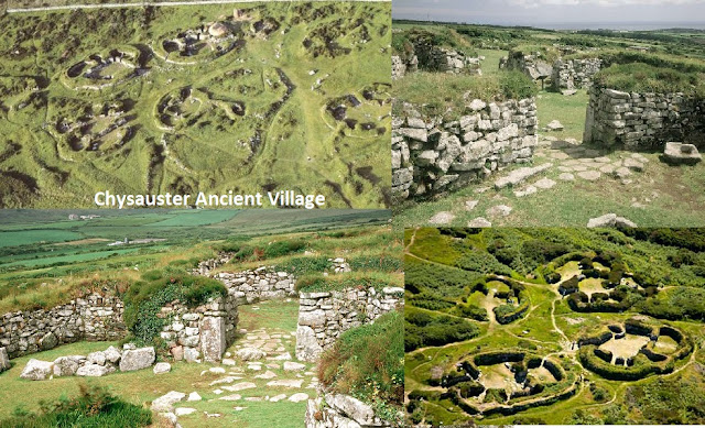
A short distance further our alignment passes through two ancient settlements that are both examples of "courtyard house settlements". First, just 1.33 miles (2.15 KM) up-line from Madron Well is Crankan Settlement near Newmill, then another 1.37 KM (4,490.6 ft) is Chysauster (pron. "tche-ZOY-ster") Ancient Village which is one of the best known & best preserved example of a courtyard house settlement.

Courtyard Houses
Courtyard Houses are a style of roundhouse found extensively in Penwith dating from the late Iron Age to the Romano-British period, the fashion probably spreading from Europe. They are usually to be found at the head of, usually earlier established, field systems.
They consist of a grouping of separate rooms of different shapes & sizes ensconced within an oval surrounding wall leaving an open courtyard central. They were constructed of stone with thatched, wooden or turf roofs, some had water courses diverted through the courtyards. They are usually built over earlier, more basic roundhouses from as early as the Bronze Age.


Plan 1, a typical courtyard house

Pic.13, A reconstruction of what a Courtyard House may have looked like inside

Pic.15, Chysauster courtyard house settlement, Penwith,Cornwall
Chysauster's courtyard houses date from the Romano-British period with the remains of simpler Iron-Age hut circles also found though habitation & field systems in the surrounding area have been found to date from as early as the Bronze Age. The 10 courtyard houses are arranged in a "village" layout & also, like Carn Euny previously mentioned, has a Fogou (pron. FOO-goo) which is the Cornish term for a souterrain or underground passage. Unlike Carn Euny the passage is not open due to structural instability.

Pic.16, How Chysauster Ancient Village may have appeared at it's peak (painting by Peter Urmston)
After passing close to Trink or the Glew Mine Menhir on top of Trink Hill, with it's tumuli & "Twelve O'clock Rock" natural boulder, then coming close to the site of a buried Fogou at Carbis Bay, our alignment leaves the shores of the Penwith peninsular & crosses St. Ives Bay to run through Godrevy Point, which was a neolithic headland settlement with a round barrow. Another 9 miles (14.48 KM) oversea brings it about 80 meters (262.46 ft.) off St. Agnes Head.

The alignment comes ashore at Penhale Sands near Perranporth where St. Piran (known locally as Perran) was said to have came ashore from Ireland on his millstone.The line passes close to St. Piran's Oratory & Church which it is said he built close to the spot where he came ashore (see satellite image below). At this point the parallel line (CLB - Seahenge) runs along Perran Round.

In my last post (https://ancientwhisperspenwith.blogspot.com/2019/03/the-carn-les-boel-seahenge-drombeg.html) that follows the parallel, there is a short piece on St. Piran/Perran which I will reproduce below as it is relevant;
Saint Piran (Perran)
St. Piran (Cornish; Perran) was a 6th century abbot saint who, is credited with, amongst other things, rediscovering tin mining in Cornwall. He is one of the three important saints, of many, in the region along with St. Petroc & St. Michael.
He has been identified as the Irish St. Ciarán of Saigir with an adapted pronunciation but there are some arguments against this.
Legend has it that the heathens of Ireland tied him to a millstone & rolled him into a turbulent sea. On contact with his holy person the towering waves were said to have become calm & he floated out to sea on his millstone until he had crossed the Irish Sea & landed on the sands of Perranporth in Cornwall. The millstone may refer to the fact that the Celtic saints used to carry a large, flat stone bowl around their necks used as a portable altar.
The people of Perranporth (along with other Cornish towns) celebrate St. Piran's day with a holiday on & around the 5th of March including parades, story telling, feasts & entertainment.
St. Piran's flag is the recognised banner of Cornwall. It consists of a white cross on a black background & early usage (15th century) includes on the coat of arms of the Saint-Peran family.

pic.17, St.Piran's flag
St. Piran's Oratory
St. Piran's Oratory was used as a place of worship for centuries. It is probably an early Christian chapel & burial ground. Like Madron Ancient Chapel mentioned earlier, it has a stone bench running round most of the interior, an altar (rebuilt around 1843) & a small nave & chancel.
In the late 1800's it was noticed that the structure was being deformed by surging sand so a protective concrete wall was built around it. During this work a number of skeletons were unearthed including one of a woman with a child in her arms. Also three enigmatic stone heads have been found there, one of a woman.
It is said that the oratory had to be abandoned because local tin streaming had altered the course of the river & flooded the site, - quite an irony for the Saint who was responsible for reintroducing tin production into Cornwall, & so St. Piran's Church was built close by. Others have suggested that both structures were in use for some time.
The eight foot stone cross that stands nearby is one of the oldest in Cornwall, dated as before 960 AD (Charles Henderson) along with the Penzance Market Cross that now stands in Penlee Park, Penzance (before 924 AD - R.A.S. Macalister) & the Doniert Stone (cross fragment) in St. Cleer, on Bodmin Moor which was said to commemorate King Dumgarth who died in 878 AD.

Pic.18, St. Piran's Oratory, stone head & nearby cross
St. Piran's Church
The structure of St Piran's Church dates from around the 12th century although there is evidence found of earlier buildings & even arable field systems on the site. it was abandoned in the 19th century due to sand encroachment. While in use in the 1700's it was normal to have to dig the sand away to gain access.

Pic.19, St. Piran's Church
After clipping the northwest corner of the village of Cubert, named after another Celtic Saint, St. Cubert or St. Cuthbert of Wales, our alignment passes close (200 meters [656.16 ft.]) to Treringey Round as it enters the southerly edge of the town of Newquay.
Shortly after the line runs through the village of St. Columb Minor & just 150 meters (492.12 ft.) from it's 15th century church which is dedicated to St. Columba the Virgin, a female saint who was martyred in the area.
As shown in my previous post, the Carn Lês Boel - Seahenge parallel alignment passes close (500 M/ 1640.4 ft) to the other church in the area dedicated to this Saint at St. Columb Major. So each alignment has it's St. Columba church.

Sat. image 11, The parallel alignments passing both St. Columba Churches at St. Columb Minor & St. Columb Major
10 miles up-line our alignment passes close-ish (400 meters/1312.3 ft.) to St. Breock Church (St. Briocus). Then 6.5 miles (10.46 KM) further near Michaelstow on the approach to Bodmin Moor, it passes three Iron Age sites within 3 miles (4. 82 KM) (see sat. Image & map below)
First a hillfort at Pengenna near Treburgett. Then we pass 350 meters (1148.2 ft.) from the remains of Helsbury Castle, a larger hillfort with a single bank, with evidence of dry-stone walling & external ditch, also the remains of a building said to be St. Syth's Chapel. A little further we pass a hilltop Cornish Round at Kenningstockmill near Helstone (Sat. Image below).
First a hillfort at Pengenna near Treburgett. Then we pass 350 meters (1148.2 ft.) from the remains of Helsbury Castle, a larger hillfort with a single bank, with evidence of dry-stone walling & external ditch, also the remains of a building said to be St. Syth's Chapel. A little further we pass a hilltop Cornish Round at Kenningstockmill near Helstone (Sat. Image below).


Shortly after, the alignment passes very close (70 M/ 229.6 ft.) to Tresinney Church (St. Adwena) before reaching the point where we cross another alignment featured in a previous post; The Tintagel - Jersey alignment (https://ancientwhisperspenwith.blogspot.com/2019/01/the-st-michaelmary-alignment-my.html).
I would love to say that there was a significant site at this crossing point, as there is for it's parallel partner at the Rough Tor settlement, especially as it forms a perfect 50 degree (general/geometric solstice) cross, but apart from a nearby (450 M/1476.3 ft. away) burial mound (Tumulus) there is little apparent. If you click on the satellite image below to enlarge, it can be seen that the Tintagel - Jersey alignment passes close to a hill-top cairn. also the road leading from Tregoodwell to Rough Tor (Roughtor Road) runs in a very similar direction to the alignment, perhaps an ancient track-way or even a solstice procession.

As the alignment clips the northwest corner of Bodmin Moor it passes close to an ancient cross near Trelay before passing very close (100 M./328.08ft.) to a pair of hilltop burial mounds in Wilsey Down Woods.
Another 9.5 miles (15.29 km) up-line & we pass close to North Tamerton Church (St. Denis) & Holy Well before crossing the river Tamar which is the natural boundary for the Duchy of Cornwall, & so into the county of Devon.

18 miles (28.97 km) into Devon & we pass by Beaford Church (St. George & All Saints) this seems to be all that Devon has to offer for this particular alignment because another 20 miles (32.19 km) we enter Exmoor & the county of Somerset where the line passes close to Brightworthy Barrows hilltop tumuli. Then just 2.5 miles (4.02 km) it hits Hernes Barrow near Withypool. Shortly afterwards (1.18 km/3866.2 ft.) we pass Road Castle Earthwork near Exford. This is a square, hilltop Iron Age fort atop a promontory caused by the River Exe meandering around it.

Then after passing Wooton Courtenay Church (All Saints) & passing through the town of Minehead, we enter the Bristol Channel & hit one of a pair of small islands; Flat Holm.

In the previous post I explain that when the accompanying alignment (Carn Lês Boel - Seahenge; https://ancientwhisperspenwith.blogspot.com/2019/03/the-carn-les-boel-seahenge-drombeg.html) ran along the island of Steep Holm, I thought to check if there was a parallel alignment that ran against the partnering island of Flat Holm which resulted in this study. For a short piece on Steep Holm please refer to that previous post.
Steep Holm & Flat Holm (Welsh; Ynys Echni) are a continuation of the Mendip Hills with the former lying in England & the latter in Wales. The small islands have been used throughout history, even before they were islands; worked flints have been found on Steep Holm dating from the Neolithic (9000 B.C. - 3000 B.C.) & even from the Mesolithic period (10,000 B.C. - 8000 B.C.) & a neolithic axe has been discovered on Flat Holm when the isles were more than likely hills.

Pic.21, Flat Holm (left) & Steep Holm, Bristol Channel
Flat Holm
Flat Holm, like it's partner island Steep Holm has a long history of usage, evidence from the Neolithic era & settlement from the late Neolithic/early Bronze Age has been discovered & also a bronze axe - head. There was Anglo Saxon settlement & evidence that it was , like Steep Holm, used also for a Viking raiding base.
In the 6th century the island was a hermitage home for Saint Cadoc while his friend St. Gildas lived on Steep Holm. The two used to meet up for prayers.
A number of early Christian graves have been discovered there some with skeletons that had been doused with lime indicating a contagious disease as the cause of death

Pic.22, Flat Holm (Ynys Echni) Bristol Channel, Wales
As the satellite image below shows, the alignment comes ashore again at the English end of the original Severn Bridge at the small village of Aust where there is an ancient Chapel (St. John) & is also the terminus of a major Roman road which came from Cirencester. We have now passed into the county of Gloucestershire .
Just 3 miles (4.83 km) further & it passes next to an Iron Age fort at Oldbury-on-Severn known as Oldbury Camp or locally as The Toot (see satellite images below).

Sat. Image 16, Land's End - The Wash alignment (above) coming ashore at Aust Cliff & passing Oldbury-on-Severn


First Haresfield Hill (see pic. & map below). It passes straight through an Iron Age hill fort on a hill with spectacular views which would have been advantageous throughout the ages hence the older burial mounds (tumuli) & later Romano Era settlement that has been discovered within the fort.

 Map 8, Haresfield Hill
 Sat. image 19, Land's End - The Wash alignment at Painswick Beacon Iron Age Fort
Straight afterwards (1.12 km/3664 ft further) the line crosses Cranham Corner first passing a Pillow Mound then crossing an earthworks on the other side.
 Sat. image 20 & Map 9, Land's End - The Wash alignment at Cranham Corner
 Sat. Image 21, Pillow Mound & Earthworks at Cranham Corner, High Brotheridge Hill Fort & Great Witcombe Roman Villa, Cotswolds, Gloucestershire

Sat. Image 17, Oldbury Camp or "TheToot" Iron Age fort, Oldbury-on-Severn

Map 7, Oldbury Camp or "TheToot" Iron Age fort, overlooking the Oldbury Pill inlet
Then another 5.8 miles (9.33 km) we pass close (400 meters/1312.34 ft.) to Berkley Castle at Berkley which is an 11th century castle famed for being the site of the torture & murder of King Edward II in 1327.

Pic.23, Berkley Castle, Berkley, Gloucestershire
The Cotswolds
Just over 10 miles (16.09 km) further & we're in The Cotswolds where the alignment becomes very busy & precise, in a short distance bulls-eyeing lots of Iron Age hill forts amongst other features on the escarpments & promontories that offer those spectacular Cotswold views.First Haresfield Hill (see pic. & map below). It passes straight through an Iron Age hill fort on a hill with spectacular views which would have been advantageous throughout the ages hence the older burial mounds (tumuli) & later Romano Era settlement that has been discovered within the fort.

Sat. Image 18, Haresfield Iron Age hill fort & The Bulwarks, Haresfield Hill
 Map 8, Haresfield Hill
Then just 2.86 miles (4.60 km) we pass along the impressive & well preserved ramparts of Painswick Beacon Hill Fort (see satellite image below). Apparently the ramparts are the best preserved aspect although there are Iron Age earthworks on the top, it has been much altered having in 1643 housed the army of King Charles I during the Civil War & today much of the site is covered by a golf course.
Just like all the Cotswold forts, Painswick Beacon offers stunning views & vantage.
Just like all the Cotswold forts, Painswick Beacon offers stunning views & vantage.
Straight afterwards (1.12 km/3664 ft further) the line crosses Cranham Corner first passing a Pillow Mound then crossing an earthworks on the other side.

Then a mere 570 meters further along, the alignment first runs against High Brotheridge Hill Fort which is also Iron Age. It is very large but hasn't been the subject of much study. Again it is an area of great beauty
Then (800 meters/2624.6 ft further) cuts right through Great Witcombe Roman Villa (see satellite images below).
Then (800 meters/2624.6 ft further) cuts right through Great Witcombe Roman Villa (see satellite images below).


Sat Image 22, Land's End - The Wash alignment at Great Witcombe Roman Villa

Pic.24, Great Witcombe Roman Villa
Crickley Hill rises from the northeast & comes to a very prominent triangular point (see satellite image below). Again this point offers beautiful & wide ranging Cotswold views & it is on this promontory that the settlement lies.


Pic.25, Crickley Hill, Cotswolds, Gloucestershire
Crickley Hill Fort & Multi-Age Settlement
In contrast to the previous hill fort, Crickley Hill has undergone extensive archaeological investigation & much has been learned about this stunning promontory enclosure from it's signs of habitation throughout the ages & for 4000 years. The site has been excavated from 1969 - 1993 & the results have made it one of international archaeological importance.
Unlike the forts & settlements in West Cornwall, the enclosure & Iron Age fort has experienced regular historic violence, seemingly from very early on.
The earliest structures discovered date from 3600 - 2500 BC & include a fully palisaded enclosure that was attacked & rebuilt several times. Hundreds of "leaf" flint arrowheads have been discovered around the entrances & evidence that the palisades & structures had been burned down. The site was periodically abandoned & rebuilt several times during this era.
The Iron Age was just as violent, the fort that was then built underwent several attacks & captures. The fort was finally abandoned before it's defences could be completed.
The post Roman era saw further settlement & dwellings that were finally abandoned about 500 AD.
The Long Mound - 3100 years of ritual
From 5500 years ago, in the Neolithic era a ritual site was developed here (The Long Mound) first consisting of a fully fenced "processional way" leading to a shrine. Evidence of fire ritual & animal sacrifice were unearthed here. later developments include a small stone circle (no longer there) with a hearth. This ritual site was in use from 5500 years ago in the Neolithic to 2400 years ago in the Iron Age. As can be seen in the satellite images, our alignment passes the very point where this occurred.
More detail can be read on the notice board pictures below - CLICK ON THE IMAGES TO ENLARGE.

(Click on image to enlarge)
Fig's 1,2,3 & 4, Crickley Hill Settlement information boards;
(Click on images to enlarge)
(Click on images to enlarge)
1

2

3

4


Pic.26, Crickley Hill Promontory, Cotswolds,Gloucestershire
Next, & again a very short distance away (1.5 miles/2.42 km) our line crosses Leckhampton Hill & runs close (350 meters/1135 ft) to the Iron Age settlement there (satellite image below). This is yet another hilltop site with panoramic & far ranging views, Iron Age enclosures & barrows. Also there is a feature here known as The Devil's Chimney which is an enigmatic pillar of natural rock that rises up & dominates the surroundings (see pic. below). I'd love to say that this "rock deity" was the reason for the location of the settlement etc. Some believe it is from natural erosion but in fact it is almost certainly the result of pretty intense quarrying during the 18th century. It is still a striking feature.


Pic.27, Leckhampton Hill Iron age Settlement

Pic.28, "The Devil's Chimney" Leckhampton Hill, Gloucestershire
Then after passing by Charlton abbots church (St. Martin) & about 1 mile (1.7 km) from the amazing Belas Knap Long Barrow, we pass within 550 meters (1804.4 ft) away from Roel Hill Camp near charlton Abbots which is one of Gloucestershire's oldest hill forts dating from the late Bronze Age/ early Iron Age.
shortly after we pass through the village of Temple Guiting & it's Church (St. Mary), then close to the church at Stretton-on-Fosse (St. Martin).
After this we leave the county of Gloucestershire & the Cotswolds & enter Warwickshire. 7 miles (11.26 km) further on from Stretton-on-Fosse the line runs close to Oxhill Church (St. Lawrence), then another 7.5 miles (12.07 km) quite close to Fenny Compton Church (St.'s Peter & Clare) although closer to the Methodist Church there. Then, just 2 miles (3.23 km) further the alignment hits the remains of the deserted Wormleighton Medieval Village.

Throughout Warwickshire & into Northamptonshire there is something of a paucity of ancient sites so the events along the alignemnt tend to be close passes of churches, I will state these in list form with distances between each:
2 miles (3.22 km) from Wormleighton we pass close to Priors hardwick Church (St. Mary), then 1.5 miles (2.09 km) further close to Priors Marston Church (St. Leanord).
After this we pass from Warwickshire into Northhamptonshire & 2.15 miles (3.46 km) on it runs through the site of Lower Catesbury Priorywhich was a priory of Cistercian nuns founded around 1175 & dissolved in 1536 (see map & satellite image below)

After passing through Daventry we pass 190 meters (623.36 ft) from The Mounts Ring & Bailey in Long Buckby. The most visible earthworks here are said to be from the Medieval period although a Neolithic polished stone axe has been found nearby. The alignment also passes close to Long Buckby Church (St. Lawrence).
Events on the line are sparse for the next 34 miles (54.71 km) apart from bulls-eyeing Maidwell Church (Mary the Virgin) & passing close to Weldon Church (Mary the Virgin) in the town of Corby, until we pass through the site of the Medieval Village of Sibberton near Sibberton Lodge close to the city of Peterborough (see satellite image & map below)


Then an uneventful 32 miles (51.50 km) further & we run into the county of Lincolnshire & finally reach the coast at The Wash.

So, end of the UK mainland, no more sites, end of the line right? - not quite.
As shown in the satellite image below, when I mapped the lower parallel alignment (Carn Lês Boel - Seahenge; https://ancientwhisperspenwith.blogspot.com/2019/03/the-carn-les-boel-seahenge-drombeg.html) I had a fine & definite feature to mark the northeast end which was "Seahenge" the site of two early Bronze Age timber circles. As there is no site on this current alignment marking it's passing into the North Sea it got me wondering what sites lie underneath the large, square estuary of The Wash & after reading about archaeological finds underneath the North Sea (& a program on the radio) I realised that the parallel alignments pass along the since submerged land of the Dogger Bank.


Pic.29, "Seahenge" early bronze age timber circles (Holme I & II)
Holme-next-the Sea, Norfolk

The Dogger Bank
Dogger Land is a now submerged land beneath the North Sea (see map above). It is named after the Dogger Bank, an area between England & Denmark that was the last to submerge. Many archaeological finds have been retrieved from beneath the North Sea including a barbed harpoon made of red deer antler. This item was long considered to be a Mesolithic (middle stone age) artifact but carbon dating revealed that it was in fact from the Upper Paleolithic (later old stone age) era meaning that it was around 12000 years old. Other artifacts found beneath the North Sea include flints, mammal bones such as a mammoth skull, Rhinoceros teeth etc., lots of worked flints & peat containing evidence of flora.

Pic.30, Paleolithic harpoon of red deer antler dredged from beneath the North Sea
A lot of finds have come from the greater Doggerland area but more recent evidence suggests that the vast lagoon abutting the lower part of the Dogger Bank may have better preserved artifacts.
As can be seen in the maps below, the lower part of the Dogger Bank escaped the glaciation of 20,000 years BC & provided a bridge from Northern Europe to what is now mainland Britain, between the glaciers & the lagoon.
I have drawn in the Parallel alignments on these maps & it can be seen (just!) that they cross this area to the south of the Dogger Bank next to the lagoon.


Recent genetic testing has suggested that the east side of the UK was inhabited by the Mesolithic peoples of North East Europe who came across the lands that now lie under the North Sea, where as the western side of Britain was inhabited by ancients who originated from Iberia.
The southwest end of the alignment doesn't run in the direction of Spain/Iberia but it does run across a proposed site of Atlantis (see map below) from where the Basque people of Iberia claim to originate from. Interesting that the native people of Cornwall & especially Penwith have been found to have genes in common with the Basque people.
It's fanciful but does this line connect the peoples of 2 sunken lands? the Dogger Bank & Atlantis?

As close as I get to a conclusion - just an idea really
It has been shown in previous posts that not only ancient sites but relatively modern constructions lie on these alignments; The St. Michael/Mary alignment enters Mounts bay at the root of Newlyn Pier, the Land's End - the Wash alignment comes ashore from the Bristol Channel at the root of the Severn Bridge, the Whipsnade Lion chalk hill figure, which was created in 1933 to advertise the wildlife park, has it's front paw on the St. Michael/Mary line.
Because our actions today are very consciously planned we expect that anything arranged in a geometric fashion must have been done consciously. These alignments have their own energy that can be detected by dowsers etc. Could ancient humans have travelled these lines subconsciously as their homelands became inundated, perhaps in the same era, using the natural travelling energy lines just like beasts of the air , sea & land when migrating?
It has been proved by genetics that the east side of the country was inhabited by the ancient peoples of the North Sea, while the westerners are descended from the ancients of Iberia. Did they end up here by subconsciously travelling these lines? Is the reason that Crickley Hill neolithic settlement was the scene of much violence in that era because it is one of the places where those different ancient people met? Speculative, of course but worth considering.

Sat. Image 31, The Whipsnade Lion (1933) with it's front paw on the St, Michael/Mary alignment
& now to round off....
Some parallel alignments duel "coincidences"
1. Both alignments have natural, slot type arches at their southwest end - open from 130 degrees - 50 deg, - the same direction as their alignments. which is from the decimal/general winter solstice sun set to the dec./gen.. summer solstice sun rise; The Carn Lês Boel - Seahenge line at Nanjisal Bay & the Land's End - The Wash line at The Peal, Land's End (see pic. below).

Pic.31, Natural arches facing same direction as alignments at Nanjisal Bay (CLB) & Land's End
2. St. Piran (Perran), the patron Saint of Cornwall, came ashore at Perranporth & built his Oratory near where he landed. The Land's End - The Wash line passes this spot & runs close to St. Pirans Oratory & Church while the CLB - Seahenge line runs against Perran (St. Piran's) Round (see satellite image below).

Sat. Image 32, parallel alignments at Perranporth
3. Both alignments run past St. Columba Churches, the CLB - Seahenge line at St. Columb Major & the Land's End - The Wash line at St. Columb Minor (see satellite image below)

Sat. image 33, parallel alignments at Perranporth, Cornwall
4. Both alignments run past the islands in the Bristol Channel, CLB - Seahenge line at Steep Holm & Land's End - The Wash line at Flat Holm (see satellite image & pic. below)

Sat. Image 34, Parallels at Flat Holm & Steep Holm, Bristol Channel

Pic.32, Steep Holm & Flat Holm, Bristol Channel
No comments:
Post a Comment