
Pic.1, Carn Galver Neolithic tor enclosure, looking from the south east tor to the north west tor & the propped stone structure (inset)
Carn Galver in the parish of Zennor, Penwith, Cornwall is nowadays more often than not spelled just so; with an "er" but the local, older spelling "Galva" invites a better pronunciation & I prefer this spelling. I will leave it spelled "Galver" in the title but from now refer to it as "Galva"
It is a place I am quite familiar with, it having been one of my favourite places to visit for years & I can't recall how many times I've clambered over a strange arrangement of granite rocks that lies close to the path between the two peaks of the south east tor, thinking it must have been something to do with quarrying for local mine structures or something.
In 1987, after a serious gorse fire, enclosure walls were (re)discovered & Carn Galva was identified as a Neolithic (New Stone Age in UK - from 4500 - 6000 years old) tor enclosure & probably the site of the since forgotten site of "Castle Anowthen" (Cornish; castle an oghen - castle of oxen) recorded in 1584.
I finally examined the curious granite structure & a number of quite remarkable functional properties were revealed (connecting with surrounding ancient features) that are fully apparent to anyone who may look today.
When I had the idea to do this post I thought it would just be an examination of this structure, as it is largely unrecognised, & quite Penwith-centric but it turns out that it has certain solar/lunar directional alignments that make it very relevant to all other posts so far.
Carn Galva (karn GAL-va) is one of the many enigmatic granite tors (known locally as "carns" = natural rocky outcrops - not to be confused with "cairns" (Scottish) = usually ancient man made rock piles for memorial or landmarks) that lie along the north west facing, breathtakingly beautiful cliff coast of Penwith in south west Cornwall, U.K. stretching from St. Just to St. Ives.
The name probably comes from the Cornish; carn = tor, rocky outcrop, crag, & golva = look out, especially as it lies on the high ground of Penwith (the carn itself reaching 817ft./249m) with spectacular, panoramic views & being situated next to a hill called Watch Croft which is the actual high point of Penwith (827ft./252m) but only a few feet higher than the peaks of C. Galva. Also, for "Galva", the Cornish word golowva meaning beacon has also been suggested & the site is recorded as having been a fire beacon site but it is less likely.
(Click on any image to enlarge)

Pic.2, Carn Galva, NW tor (left), SE tor (right) & Carn Galver Mine engine house (ruin)
The carn itself has been identified as one of Penwith's four (so far) Neolithic tor enclosures & lies in a small area of moorland known as Boskednan Moor which is home to a large number of ancient sites including Nine Maidens (Neolithic) Stone Circle, the Mên-an-Tol (meyn-an-TOL - Cornish; stone with a hole), Mên-Scryfa (meyn SKREE-fa - Cornish; stone with an inscription), Venton Bebibell Holywell (venton be-BI-bell - Cornish; well of the little people) & lots of burial mounds (tumuli).

Pic.3, (a) Mên-an-Tol & (b) Mên-Scryfa with Carn Galva SE tor

Pic.4, Venton Bebibell Holywell with Carn Galva SE tor in background,

Boskednan Moor forms the highest part of Penwith with Watch Croft, the next hill to the south west of Carn Galva, being the actual high point. It is said that, on an extraordinarily clear day, both Rough Tor & Brown Willy (both of which are also Neolithic tor enclosures) can be seen up on Bodmin Moor (over 50 miles away) from Carn Galva.
The Apollo/Athena Alignment runs across Watch Croft & Boskednan Moor after coming ashore nearby. In fact the Dowser & Blacksmith Hamish Miller states in his book "The Dance of the Dragon" (in which he dowses the Apollo/Athena alignment) that the Apollo energy line passes between the peaks of the south-east tor of Carn Galva & as our structure is quite inconspicuous, it might pass through this actual feature.
(For a short study of the Apollo/Athena alignment & some ancient sites on Boskednan Moor see previous post -https://ancientwhisperspenwith.blogspot.com/2019/02/the-st-michael-triangle-duke-line.html )

Sat.image 1, Carn Galva & other ancient features on Boskednan Moor
(click on image to enlarge)

Sat. image 2, Penwith, Cornwall with Carn Galva & some prominent headlands/cliff castles
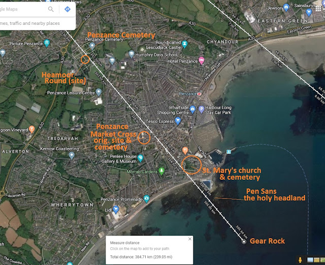
As can be seen on the satellite image above, Carn Galva lies towards the north west coast of Penwith but, as it lies on the higher ground, (St. Michael's) Mount's Bay can clearly be seen towards the south east.
The following link provides a spectacular 4 minute aerial view (by drone) of Carn Galva. Note that St. Michael's Mount is clearly visible on the more distant (south east) coast, this fact is important for the following study of the stone structure on the carn.
click on this link for Aerial Carn Galva (4 minute video by; Danny's Drone Addiction); - https://www.youtube.com/watch?v=O4SvBGj3KqI

Pic.6, St. Michael's Mount, Mount's Bay, south west Cornwall

Boskednan Stone Circle, also known as Nine Maidens even though it is thought to have originally consisted of 22 stones of which 10 remain today, lies exactly 1km (3280.84ft.) to the south east from the SE tor of Carn Galva. It is a Neolithic site so contemporary with the enclosing of the carn.
Neolithic propped stones
The people of the Neolithic period in Britain (4500 - 6000 years ago) marked their territories with large slabs or boulders propped up on smaller rocks. The reason has never been fully understood, they may be monuments of human achievement or the beginning of the understanding that balance is the secret of construction, but these monuments almost definitely would have acted as landmarks or territorial markers, some are said to frame certain sun sets or rises. They can be found all over Europe & other areas of the world including the Middle East.

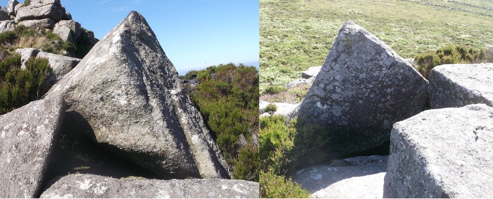
Carn Galva has many propped, lodged, perched & placed stones including boulders propped on small rocks, slender menhirs positioned on the skyline as directional indicators & at least two triangular locational markers also on the skyline.


Cornish Logan Stones
There are many perched or poised boulders in the U.K. & elsewhere but in Cornwall, especially in Penwith, they are referred to as logan stones. "logan" is a local dialect word from the English "logging" meaning rocking or swaying but also said to be used in dialect by the Cornish to describe the swaggering gait of a drunk person. People tend to use the anglicised pronunciation "LOW-gan" but it is supposed to be pronounced "LOGG-un". Logan stones do not have to actually rock (some do, or did in the past), in fact there are at least two that are/have been referred to as "Men Amber" from the Cornish; men = stone & omborth = poised or balanced. So perhaps it was the balancing aspect of the exercise rather than achieving the rocking motion.
The famous Logan Rock of Treryn Dinas (see pics below) promontory fort near Porthcurno in Penwith was said to have been easily rocked with one hand until one night in April 1824 it was toppled from it's position in an arrogant show of strength by Lieutenant Hugh Goldsmith RN with the aid of a dozen or so of his men, probably after taking refreshment at the local inn (also called The Logan Rock). This caused much anger & resentment among the local residents who relied on the tourism that this famous attraction brought & so a petition was submitted to the British Admiralty to strip the lieutenant of his commission unless the rock was replaced & restored to it's previous rocking ability. After much effort & expense It was replaced on 2nd of November 1824 but now only rocks slightly after much applied effort.
On the southern slope of Trencrom Hill Neolithic tor enclosure near Lelant in Penwith, can be found a huge & beautiful granite boulder that is propped with a smaller rock. Only a tiny part of it's surface area connects it to the ground & looks like it could possibly rock if it was unwedged (see pic. 15 below). The propping of this stone does not look ancient as the propping rock has too sharper edges to appear Neolithic ( 4500 - 6000 years old) & I have heard that over 100 years ago Lelant Church (St. Uny) boasted of wedging a local logan stone, unpopular with the church as these stones were associated with witches & giants. This boulder could definitely be a candidate for this story, especially as St. Uny's in Lelant would have been the closest parish church. But then again, it could also be an ancient propped stone, propped up on it's smallest connecting area.

 Pic.13, A large perched boulder (logan stone) at a hilltop ancient settlement on Boswarva Carn, 1.73 miles (2.78 km) from Carn Galva


As you climb up the track in between the two peaks you are met with a breathtaking view of the north coast stretching from Bosigran Cliff Castle to Zennor Carn. The view is quite suddenly presented because the Boskednan Moor side (SW approach) is high ground and the north east side of the carn drops rapidly down to the coastal cliffs & then down again to the sea.
If you keep your eye on the triangular skyline marker the propped stone structure can easily be located to your left. The structure itself is very simple & unassuming, some might say quite crudely constructed, consisting of a granite stone slab that has been split along two straight quartz veins into three sections, two long cuboid "fingers" & an irregular angular shape (see pic. 21 above). The longest (the easternmost) has been pulled slightly forward (to the NNE), positioned against the next & the right side has been propped up on a small rock to make it level (see pic. 22 below). the positioning of the lozenge creates a sharp angle at the rear & the triangular marker stone has been positioned at the back to make a three sided box, open to the south east.
The structure is comfortable to sit in facing south-south-west (seat 1 - see pic. 30 below) with space provided for your legs & feet (see pic. 24 below). In this position the eye is drawn to the distant rocky outcrop called Carn Kenidjack (https://cornishbirdblog.com/2018/09/01/carn-kenidjack-the-hooting-cairn/) which can clearly be seen crowning the horizon to the south-west, exactly 5 km (3.11 m) away towards St. Just & at exactly 230 degrees which is the decimal winter solstice orientation. It is interesting to note that this location (between the peaks of the SE tor) is the only spot on either of Carn Galva's tors where Carn Kenidjack is visible because if you move back along the carn from here it becomes obscured by Watch Croft, the highest point of Penwith.


Carn Kenidjack, also known as the "hooting Carn" is/was also a Neolithic tor enclosure having two large granite outcrops on either side of the south west face making enclosure simple with a straight wall between them - much like the SE tor of Carn Galva. It is a very noticeable & iconic landmark & is even visible from the Isles of Scilly over 30 miles (48.27 km) away.
It stands at the top of a small common collectively known as Kenidjack, Truthwall, Tregaseal, Botallack & Carnyorth Common, but locally known as "The Gump" from it's Cornish name "Woon Gumpus" (trans; the level downland). This is an area that history records was covered in ancient monuments, many of which remain today including, barrows, cairn circles, kerbed cairns, a row of holed stones & Tregaseal stone circle; the only remaining of two proven stone circles, dated to the late Neolithic to early Bronze-Age, lying to the south-south-west of Carn Kenidjack. There are at least two other stone circles of unknown age more irregular & constructed with small boulders, usually overgrown with gorse, further up & to the south west of the carn.


The apparent functions of the Carn Galva structure

As you sit in the structure at Carn Galva you will notice that the inner facing surface of the triangular marker stone in front of you is extremely flat whereas the outer surface is natural & bulky. If you lean forward & look along the straight edge of this stone from the rear angle of the structure (viewpoint 1 - see pic. 30 above) you will notice that it has been set exactly in alignment with St. Michael's Mount that can be seen emerging over the headland on the distant coast to the south east (see pic. below). This is then the third function of this one stone; firstly it forms part of the structure, secondly it serves as a locational skyline marker & thirdly it pinpoints St. Michael's Mount which, like Carn Galver is/was a Neolithic tor enclosure.


If this seems a little "coincidental" then there is a second precise method of pinpointing St. Michael's Mount from the structure. If you lean into the corner of the angle behind your head (viewpoint 2 - see pic. 30 above), with your eye-line at the surface of the structure, It can be seen that there is a rock on the opposite peak that has been angled to present a "shark fin" shape from the direction of the structure. St. Michael's Mount, part visible, peaking over the foreground, lies precisely at the tip of this stone (see pictures below).


The direction of this alignment is 122 deg. which is very close to the direction of the local full moon southerly minimum limit rise. The fact that the stone indicates St. Michael's Mount, rather than the Lizard Peninsula on the horizon above, suggests it is a locator for the mount rather than for the full moon rise.
So we have two methods of pinpointing St. Michael's Mount with the structure but no pinpointing method for Carn Kenidjack, that would probably be because you would not need one. Carn Kenidjack stands proud & obvious on the horizon whereas St. Michael's Mount peeks, only part visible, over the line of the foreground. If you think it is still pretty detectable then perhaps it's location was necessary in weather with less visibility, or perhaps because of another reason;
The old Cornish name for St. Michael's Mount was "Karrek Loos y'n Koos" which translates as "the grey rock in the woods". This name is remarkable as it is thought that the mount (consisting of grey Granite in a Greenstone area) has not been surrounded by trees since the Neolithic era (4500 - 6000 years ago) due to the gradual inundation of Mount's Bay. In fact the mount was almost certainly visited & chronicled in the fourth century BC. by a Greek geographer & astronomer Pytheas from Massilia. Most of his original record are lost but the surviving scraps indicate that St. Michael's Mount was a tidal island even in those times so the old name must have somehow survived thousands of years.
If the Carn Galva structure survives from the Neolithic, as do a lot of it's surrounding ancient features, chances are that St. Michael's Mount, perhaps being surrounded by trees rather than being framed by blue sea as it is today, might have been a lot more difficult to locate visually.

There is another sighting alignment & another probable seating position on the structure. Just by the back right (north-easternmost) corner of the displaced cuboid stone there is an small,angular, flat topped stone that provides a comfortable sitting position (seat 2 - see pic. 30 above) to bring your eye-line down to the very corner of the displaced stone (viewpoint 3 - see pic. 30 above). When in this position you will see that the "shark fin" indicator stone on the opposite tor now pinpoints Lizard Point, the very tip of the Lizard peninsula (see pic. below - hard to show with my limited camera equipment).
From the structure, Lizard Point lies at 130 degrees which is the decimal winter solstice sunrise so we have some major "coincidences" here; Lizard Point marks the decimal midwinter sunrise & Carn Kenidjack marks the decimal midwinter sunset. The top of St. Michaels Mount lies at 122 degrees which is 2 degrees off the decimal minimum full moon rise in the south. The three features are not only natural landmarks but they are the three most obvious natural landmarks that can be seen, two of which are other Neolithic tor enclosures & the other an important "end of the land" headland.


The chart above shows the decimal or general rises & sets for the solstices & full-moon limits, if this geometric pattern is placed with the Carn Galva structure at it's centre, we will see that each orientation links with significant ancient (& also iconic natural) features of the surrounding landscape.
The decimal or general solar/lunar limit alignments of the Carn Galva structure

When I first planned to write this post I thought I would just be doing a general description of a local unrecognised possible ancient feature & giving alignment chasing a bit of a break but it turns out this site has many remarkable major alignments orientated to the decimal or general solstice & moon limit directions.
The decimal/general solar/full moon limits
The decimal or general directions are decimally rounded up orientations & not the actual solstice rises & sets for this local area, the actual location of the rises & sets (at sea level) are slightly different depending on your location on the globe. For example the local direction for the winter solstice sun-rise in my area is close to 127 degrees. I know this because I was able to see the sun rise from the sea this midwinter just gone & was able to measure it.
The decimal summer solstice sun-rise is 50 degrees (north-east), the decimal summer solstice sun-set is 310 deg. (north-west), the decimal winter solstice sun-rise is 130 deg. (south-east) & the dec. winter solstice sun-set is 230 deg. (south-west) these orientations are all 50 degrees east & west of north & south so can be joined up to form a 50 degree cross, the center of which would be our point of view.
The decimal northern minimum limit for a full moon (i.e. the closest full moon to the equinox [90 deg.- 270 deg.] in the north) rise is 60 degrees, the set is 300 deg. The decimal southern full moon limit rise is 120 deg. & the set is 240 deg. These points are all 60 degrees east & west of north & south & join up make a 60 degree cross which is the directions that the diagonal spurs on a hexagram point (more later).
The decimal northern maximum full moon limit (i.e. the closest full moon to north [0 deg.])) rise is 40 degrees & the set is 320 deg. The decimal southern maximum full moon limit (i.e. the closest full moon to south [180 deg]) rise is 140 degrees & the set is 220 deg. These points are 40 degrees east & west of north & south & can be joined up to make a 40 degree cross.
Put these crosses together & they form a kind of Maltese cross shape. These orientations seem to have been very important to the people of ancient times as many of the alignments featured in previous posts are in these directions; In "Avebury Geometry 1" (https://ancientwhisperspenwith.blogspot.com/2018/11/avebury-geometry.html) we discovered that the crossed edge alignments between the inner stone circles of the henge were so arranged; one from the decimal equinox rise to set & the other from the decimal full moon northern maximum rise to the southern max. set.

In "Avebury geometry 2" (https://ancientwhisperspenwith.blogspot.com/2018/11/avebury-geometry-pt-2-a.html) we found that the Great Barrow & a straight line earthwork on Windmill Hill lay on the decimal summer solstice sun-set direction from the practical centre of the Avebury mechanism & also the central axis of a nearby hexagonal crop "circle" was aligned in the decimal summer solstice sun-rise direction from the centre.

The St. Michael/Mary alignment lies from the decimal northern full moon minimum rise to the dec. northern full moon minimum set. The westernmost alignments of the St. Michael Triangle are on a 60 degree (decimal full moon minimum) cross & the parallel Land's End to Seahenge alignments (https://ancientwhisperspenwith.blogspot.com/2019/03/the-carn-les-boel-seahenge-drombeg.html & https://ancientwhisperspenwith.blogspot.com/2019/07/clb-seahenge-pt-2-lands-end-wash.html) are on a decimal summer solstice rise - winter solstice set line.

I think it's important to mention that with my method of plotting alignments on satellite image I use the "measure distance" feature (right cick on mouse) which, at close range looks like a straight line but over long distance, especially internationally, it can be seen that it is in fact a curved line as it allows for the curvature of the earth & since obtaining an on-screen protractor I have discovered that the orientation varies degrees every 50 miles, for instance the St. Michael/Mary alignment is at degrees at Carn Lês Boel, it's south-west terminus, at degrees at Avebury Henge, it's centre & at degrees at Hopton, it's north-east terminus. Interestingly the St. Michael/Mary alignment is decimal (60 degrees - full moon min.) exactly at The Hurlers stone circles on Bodmin Moor where it crosses the Tintagel - Jersey alignment between the top two circles which is on a decimal mid-summer set - midwinter rise solstice alignment.
Of course alignments of ancient sites run in all directions, as one look at the Penwith alignments map (https://www.google.com/maps/d/u/0/viewer?mid=1dUcFxhue1W8H0WR-bbeAya47Zi4&ll=50.16620926667721%2C-5.4216996003417535&z=10) by Palden Jenkins will confirm, but a lot of the longer distance ones seem to be aligned on 40, 50 & 60 degree crosses. From following these lines it dawned on me that they are the perfect travelling aids as they align, not only man-made ancient features & settlements but also hills, springs, river mouths, islands, valleys, pools etc. that are all natural. I have the feeling that the people of those times were much less sedentary than we are today & may have used them for seasonal travelling cycles or even exploratory methods in times of change (ice ages etc.)
So we have already seen two very significant decimal alignments for the structure; the dec. midwinter sunrise at the visible end of the Lizard Peninsula at Lizard Point & the dec. midwinter sunset at Carn Kenidjack, actually I took the measurement from the gap in the rock formation. If we continue this line from Carn Kenidjack through the Carn Galva structure we end up at Bosigran Castle promontory fort (site) which is it's nearest ancient cliff sanctuary. This site is our third decimal solstice alignment marking the midsummer sunset at 310 degrees.
The structure has many more decimal solar/lunar alignments, in fact if you put the cross plan of the general/dec. orientations onto the Carn Galva structure many of the points connect not just with natural features that have evidence of ancient usage but with very significant & iconic natural/ancient features as we will see, many of the alignments taking in other ancient features.
First lets examine the lines we have found already & see if there are any other ancient sites aligned with them.

A. 50 deg.- 230 deg.; the decimal summer solstice sunrise - dec. winter solstice sunset alignment


This alignment is thankfully much shorter, I think of it as the Penzance connection. It is a line that runs from the decimal full-moon maximum limit set in the north (i.e. the closest full-moon set to north [N = 360/0 deg.] which is 320 deg..) to the dec. full-moon max. rise in the south (i.e. the closest full-moon rise to south [S = 180 deg.] which is 140 deg.
As Carn Galva is close to the coast the three north-west terminations of the alignments are very close together; the 300 degree line hits Porthmoina, the cliffy cove & small beach below Bosigran Cliff Castle, the 310 deg. runs through the castle itself & this one, the 320 hit's Carn Veslan which is the next promontory or headland to Bosigran Castle.

No ancient features to report at Carn Veslan Head but I can't imagine it not being used by the people of the Bosigran settlement. The alignment comes ashore over the headland, over the slightly set back carn, over the Bronze & Iron-Age field boundaries, along the western side of the north-west tor & joining saddle & as it runs through our construction on the S-E tor it can be seen that, just like enclosure wall 2 running parallel to the Porthmoina - St. Michael's Mount dec. full-moon minimum alignment back in part C., it looks like enclosure wall 1. (of which also not a lot remains above ground) runs parallel to this one which is the dec. full-moon maximum orientation. Not only that but, as shown in the satellite images below, if you follow the direction of enclosure wall 1 to the south-east you will run along the edge of a large kerbed cairn (erroneously marked as "Four Parishes Rock" on Google satellite, which actually is slightly to the north-west of the cairn at the crossing of the footpaths; https://www.megalithic.co.uk/article.php?sid=24022 & https://www.heritagegateway.org.uk/Gateway/Results_Single.aspx?uid=MCO2183&resourceID=1020 ) and after exactly 1 kilometer (0.62 miles) from C. Galva you will end up slap bang in the middle of Boskednan stone circle (https://en.wikipedia.org/wiki/Boskednan_stone_circle & https://www.megalithic.co.uk/article.php?x=143500&y=035100).


Neolithic propped stones
The people of the Neolithic period in Britain (4500 - 6000 years ago) marked their territories with large slabs or boulders propped up on smaller rocks. The reason has never been fully understood, they may be monuments of human achievement or the beginning of the understanding that balance is the secret of construction, but these monuments almost definitely would have acted as landmarks or territorial markers, some are said to frame certain sun sets or rises. They can be found all over Europe & other areas of the world including the Middle East.

Pic.8, Some Neolithic propped stones from around the U.K.

Pic.9, Some propped, perched & placed stones of Carn Galva

Pic.10, A remarkable Neolithic propped granite boulder on the saddle between the SE & NW tors of Carn Galva, propped with a rock with a decorative white quartz stripe (inset)

Pic.11, (a) skyline indicator menhir 1 guides you around the carn. (b) at a certain point menhir 1 disappears from the skyline & menhir 2 immediately appears indicating a change of direction

Pic.12, Skyline indicator menhir 2 shows the way to an flat grassy area cleared in the Neolithic era, probably for timber buildings
There are many perched or poised boulders in the U.K. & elsewhere but in Cornwall, especially in Penwith, they are referred to as logan stones. "logan" is a local dialect word from the English "logging" meaning rocking or swaying but also said to be used in dialect by the Cornish to describe the swaggering gait of a drunk person. People tend to use the anglicised pronunciation "LOW-gan" but it is supposed to be pronounced "LOGG-un". Logan stones do not have to actually rock (some do, or did in the past), in fact there are at least two that are/have been referred to as "Men Amber" from the Cornish; men = stone & omborth = poised or balanced. So perhaps it was the balancing aspect of the exercise rather than achieving the rocking motion.
The famous Logan Rock of Treryn Dinas (see pics below) promontory fort near Porthcurno in Penwith was said to have been easily rocked with one hand until one night in April 1824 it was toppled from it's position in an arrogant show of strength by Lieutenant Hugh Goldsmith RN with the aid of a dozen or so of his men, probably after taking refreshment at the local inn (also called The Logan Rock). This caused much anger & resentment among the local residents who relied on the tourism that this famous attraction brought & so a petition was submitted to the British Admiralty to strip the lieutenant of his commission unless the rock was replaced & restored to it's previous rocking ability. After much effort & expense It was replaced on 2nd of November 1824 but now only rocks slightly after much applied effort.
On the southern slope of Trencrom Hill Neolithic tor enclosure near Lelant in Penwith, can be found a huge & beautiful granite boulder that is propped with a smaller rock. Only a tiny part of it's surface area connects it to the ground & looks like it could possibly rock if it was unwedged (see pic. 15 below). The propping of this stone does not look ancient as the propping rock has too sharper edges to appear Neolithic ( 4500 - 6000 years old) & I have heard that over 100 years ago Lelant Church (St. Uny) boasted of wedging a local logan stone, unpopular with the church as these stones were associated with witches & giants. This boulder could definitely be a candidate for this story, especially as St. Uny's in Lelant would have been the closest parish church. But then again, it could also be an ancient propped stone, propped up on it's smallest connecting area.


(click on images to enlarge)

Pic.14, The Logan Rock (central) crowning Treryn Dinas promontory fort, Penwith, west Cornwall

Pic.15, The Logan Rock, Treryn Dinas near Porthcurno, replaced after being toppled by Lieutenant Goldsmith RN in 1824

Pic.16, A huge propped logan stone, Trencrom Hill, Penwith

Sat. image 3, Carn Galva SE tor, showing the locations of some of the features

Pic. 17, location of the structure on the south-east tor of Carn Galva

Pic.18, The double peaks of Carn Galva's south east tor
The Propped Stone Structure
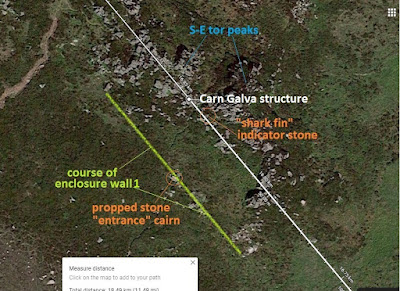
The propped stone structure featured in this study can easily be located as you approach the SE tor from the south west as there is a very distinct, triangular skyline marker stone half way up the inner slope of the left peak (see picture below). There is another triangular skyline marker, just out of shot to the right of the picture below, which I suspect marks an alignment.
As you approach this feature up an overgrown track you are met by a granite cairn featuring a large propped flat stone (see pic. 19 below). This feature lies on the spot where the enclosure wall once stood. It is in such a central position that it suggests a possible entrance point in the wall, although there is another possible cairn in the undergrowth just 40 ft. (12.19m) to the right.

Pic.19, triangular marker stone visible on the skyline, half way up the inner slope of the left peak on approach from the south west

Pic.20, Propped stone "entrance" cairn lies in the middle of the enclosure wall (site) - triangular skyline marker stone visible in the background

Pic.21, The triangular marker stone locates & also forms part of the propped stone structure

Pic.22, The propped stone structure between the peaks of the SE tor of Carn Galva
If you keep your eye on the triangular skyline marker the propped stone structure can easily be located to your left. The structure itself is very simple & unassuming, some might say quite crudely constructed, consisting of a granite stone slab that has been split along two straight quartz veins into three sections, two long cuboid "fingers" & an irregular angular shape (see pic. 21 above). The longest (the easternmost) has been pulled slightly forward (to the NNE), positioned against the next & the right side has been propped up on a small rock to make it level (see pic. 22 below). the positioning of the lozenge creates a sharp angle at the rear & the triangular marker stone has been positioned at the back to make a three sided box, open to the south east.
The structure is comfortable to sit in facing south-south-west (seat 1 - see pic. 30 below) with space provided for your legs & feet (see pic. 24 below). In this position the eye is drawn to the distant rocky outcrop called Carn Kenidjack (https://cornishbirdblog.com/2018/09/01/carn-kenidjack-the-hooting-cairn/) which can clearly be seen crowning the horizon to the south-west, exactly 5 km (3.11 m) away towards St. Just & at exactly 230 degrees which is the decimal winter solstice orientation. It is interesting to note that this location (between the peaks of the SE tor) is the only spot on either of Carn Galva's tors where Carn Kenidjack is visible because if you move back along the carn from here it becomes obscured by Watch Croft, the highest point of Penwith.

Pic.23, The displaced stone bar is propped horizontal upon a small flat rock

Pic.24, The structure is comfortable to sit in & feels like sitting in the "cockpit" of the carn

Pic.25, There is even comfortable space for your legs & feet

Pic.26, The seating position allows for the triangular stone to be used as a sun shield when observing the mid-winter sunset at Carn Kenidjack

Pic.27, Carn Kenidjack - another Neolithic tor enclosure (as viewed from the Carn Galva structure) crowning the horizon towards the south west

Pic.28, Carn Kenidjack Neolithic tor enclosure (NE side), Tregaseal Common (The Gump) between Pendeen & St. Just, Penwith, west Cornwall

Sat. image 4, the Carn Galva structure lies exactly 5 km at exactly 50 deg. from Carn Kenidjack - a decimal solstice alignment
Carn Kenidjack, also known as the "hooting Carn" is/was also a Neolithic tor enclosure having two large granite outcrops on either side of the south west face making enclosure simple with a straight wall between them - much like the SE tor of Carn Galva. It is a very noticeable & iconic landmark & is even visible from the Isles of Scilly over 30 miles (48.27 km) away.
It stands at the top of a small common collectively known as Kenidjack, Truthwall, Tregaseal, Botallack & Carnyorth Common, but locally known as "The Gump" from it's Cornish name "Woon Gumpus" (trans; the level downland). This is an area that history records was covered in ancient monuments, many of which remain today including, barrows, cairn circles, kerbed cairns, a row of holed stones & Tregaseal stone circle; the only remaining of two proven stone circles, dated to the late Neolithic to early Bronze-Age, lying to the south-south-west of Carn Kenidjack. There are at least two other stone circles of unknown age more irregular & constructed with small boulders, usually overgrown with gorse, further up & to the south west of the carn.

Pic.29, Tregaseal holed stones on The Gump

Pic.30, Carn Kenidjack (SW side) & Tregaseal stone circle, Woon Gumpus (The Gump), Penwith
The apparent functions of the Carn Galva structure

Pic.31, The Carn Galva propped stone structure from above
As you sit in the structure at Carn Galva you will notice that the inner facing surface of the triangular marker stone in front of you is extremely flat whereas the outer surface is natural & bulky. If you lean forward & look along the straight edge of this stone from the rear angle of the structure (viewpoint 1 - see pic. 30 above) you will notice that it has been set exactly in alignment with St. Michael's Mount that can be seen emerging over the headland on the distant coast to the south east (see pic. below). This is then the third function of this one stone; firstly it forms part of the structure, secondly it serves as a locational skyline marker & thirdly it pinpoints St. Michael's Mount which, like Carn Galver is/was a Neolithic tor enclosure.
Pic.32, (a) The triangular stone's outward surface is natural whereas (b) the inner surface is very flat, straight & aligned to St. Michael's Mount on the distant SE coast

Pic.33, (from viewpoint 1 - see pic. 30 above) Looking down the inner flat edge of the triangular marker stone to see that it is perfectly aligned with St Michael's Mount - another Neolithic tor enclosure (& inset)
If this seems a little "coincidental" then there is a second precise method of pinpointing St. Michael's Mount from the structure. If you lean into the corner of the angle behind your head (viewpoint 2 - see pic. 30 above), with your eye-line at the surface of the structure, It can be seen that there is a rock on the opposite peak that has been angled to present a "shark fin" shape from the direction of the structure. St. Michael's Mount, part visible, peaking over the foreground, lies precisely at the tip of this stone (see pictures below).

Pic.34, when looking south east from the structure a "sharks fin" shaped indication stone can be seen on the other peak of the SE tor

Pic.35, from the surface of the NW angle of the "box" of the structure (viewpoint 2 - see pic. 30 above), the "shark fin" stone's tip pinpoints St. Michael's Mount in the distance
The direction of this alignment is 122 deg. which is very close to the direction of the local full moon southerly minimum limit rise. The fact that the stone indicates St. Michael's Mount, rather than the Lizard Peninsula on the horizon above, suggests it is a locator for the mount rather than for the full moon rise.
So we have two methods of pinpointing St. Michael's Mount with the structure but no pinpointing method for Carn Kenidjack, that would probably be because you would not need one. Carn Kenidjack stands proud & obvious on the horizon whereas St. Michael's Mount peeks, only part visible, over the line of the foreground. If you think it is still pretty detectable then perhaps it's location was necessary in weather with less visibility, or perhaps because of another reason;
The old Cornish name for St. Michael's Mount was "Karrek Loos y'n Koos" which translates as "the grey rock in the woods". This name is remarkable as it is thought that the mount (consisting of grey Granite in a Greenstone area) has not been surrounded by trees since the Neolithic era (4500 - 6000 years ago) due to the gradual inundation of Mount's Bay. In fact the mount was almost certainly visited & chronicled in the fourth century BC. by a Greek geographer & astronomer Pytheas from Massilia. Most of his original record are lost but the surviving scraps indicate that St. Michael's Mount was a tidal island even in those times so the old name must have somehow survived thousands of years.
If the Carn Galva structure survives from the Neolithic, as do a lot of it's surrounding ancient features, chances are that St. Michael's Mount, perhaps being surrounded by trees rather than being framed by blue sea as it is today, might have been a lot more difficult to locate visually.

Pic.36, St. Michael's Mount, Mount's Bay, west Cornwall
There is another sighting alignment & another probable seating position on the structure. Just by the back right (north-easternmost) corner of the displaced cuboid stone there is an small,angular, flat topped stone that provides a comfortable sitting position (seat 2 - see pic. 30 above) to bring your eye-line down to the very corner of the displaced stone (viewpoint 3 - see pic. 30 above). When in this position you will see that the "shark fin" indicator stone on the opposite tor now pinpoints Lizard Point, the very tip of the Lizard peninsula (see pic. below - hard to show with my limited camera equipment).
From the structure, Lizard Point lies at 130 degrees which is the decimal winter solstice sunrise so we have some major "coincidences" here; Lizard Point marks the decimal midwinter sunrise & Carn Kenidjack marks the decimal midwinter sunset. The top of St. Michaels Mount lies at 122 degrees which is 2 degrees off the decimal minimum full moon rise in the south. The three features are not only natural landmarks but they are the three most obvious natural landmarks that can be seen, two of which are other Neolithic tor enclosures & the other an important "end of the land" headland.

Pic.37, From "viewpoint 3" position of the structure (see pic. 30 above) the "shark fin" indicator stone pinpoints Lizard Point on the horizon which lies exactly 130 deg. - the decimal winter solstice sunrise

Sat. image 5, Bosigran Castle & settlement - Lizard Point, from the decimal summer solstice sunset to the dec. winter solstice sunrise from the p.o.v. of the structure

Sat. image 6, Some features of the south-east tor of Carn Galva

Chart 1, the solar/lunar limits cross - the decimal directions of the solstice &
full-moon limit rises & sets
The chart above shows the decimal or general rises & sets for the solstices & full-moon limits, if this geometric pattern is placed with the Carn Galva structure at it's centre, we will see that each orientation links with significant ancient (& also iconic natural) features of the surrounding landscape.
The decimal or general solar/lunar limit alignments of the Carn Galva structure

Sat. image 7, the solar/lunar limits cross from the perspective of the Carn Galva structure
(Click on image to enlarge)
(Click on image to enlarge)
When I first planned to write this post I thought I would just be doing a general description of a local unrecognised possible ancient feature & giving alignment chasing a bit of a break but it turns out this site has many remarkable major alignments orientated to the decimal or general solstice & moon limit directions.
The decimal/general solar/full moon limits
The decimal or general directions are decimally rounded up orientations & not the actual solstice rises & sets for this local area, the actual location of the rises & sets (at sea level) are slightly different depending on your location on the globe. For example the local direction for the winter solstice sun-rise in my area is close to 127 degrees. I know this because I was able to see the sun rise from the sea this midwinter just gone & was able to measure it.
The decimal summer solstice sun-rise is 50 degrees (north-east), the decimal summer solstice sun-set is 310 deg. (north-west), the decimal winter solstice sun-rise is 130 deg. (south-east) & the dec. winter solstice sun-set is 230 deg. (south-west) these orientations are all 50 degrees east & west of north & south so can be joined up to form a 50 degree cross, the center of which would be our point of view.
The decimal northern minimum limit for a full moon (i.e. the closest full moon to the equinox [90 deg.- 270 deg.] in the north) rise is 60 degrees, the set is 300 deg. The decimal southern full moon limit rise is 120 deg. & the set is 240 deg. These points are all 60 degrees east & west of north & south & join up make a 60 degree cross which is the directions that the diagonal spurs on a hexagram point (more later).
The decimal northern maximum full moon limit (i.e. the closest full moon to north [0 deg.])) rise is 40 degrees & the set is 320 deg. The decimal southern maximum full moon limit (i.e. the closest full moon to south [180 deg]) rise is 140 degrees & the set is 220 deg. These points are 40 degrees east & west of north & south & can be joined up to make a 40 degree cross.
Put these crosses together & they form a kind of Maltese cross shape. These orientations seem to have been very important to the people of ancient times as many of the alignments featured in previous posts are in these directions; In "Avebury Geometry 1" (https://ancientwhisperspenwith.blogspot.com/2018/11/avebury-geometry.html) we discovered that the crossed edge alignments between the inner stone circles of the henge were so arranged; one from the decimal equinox rise to set & the other from the decimal full moon northern maximum rise to the southern max. set.
Plan 1, crossed edge alignments of the inner circles at Avebury showing decimal equinox & dec. full moon max. directions
(from prev. post Avebury geometry part 1)

Pic.38, & plan 2, crop hexagram at Avebury at decimal midsummer rise direction & combining with other decimal alignments (from prev. post Avebury geometry part 2)
(photo. by Steve Alexander)
The St. Michael/Mary alignment lies from the decimal northern full moon minimum rise to the dec. northern full moon minimum set. The westernmost alignments of the St. Michael Triangle are on a 60 degree (decimal full moon minimum) cross & the parallel Land's End to Seahenge alignments (https://ancientwhisperspenwith.blogspot.com/2019/03/the-carn-les-boel-seahenge-drombeg.html & https://ancientwhisperspenwith.blogspot.com/2019/07/clb-seahenge-pt-2-lands-end-wash.html) are on a decimal summer solstice rise - winter solstice set line.

Sat. images 8, St. Michael/Mary, St. Michael triangle & Land's End - Seahenge alignments at decimal solar/lunar limit directions (from previous posts)
I think it's important to mention that with my method of plotting alignments on satellite image I use the "measure distance" feature (right cick on mouse) which, at close range looks like a straight line but over long distance, especially internationally, it can be seen that it is in fact a curved line as it allows for the curvature of the earth & since obtaining an on-screen protractor I have discovered that the orientation varies degrees every 50 miles, for instance the St. Michael/Mary alignment is at degrees at Carn Lês Boel, it's south-west terminus, at degrees at Avebury Henge, it's centre & at degrees at Hopton, it's north-east terminus. Interestingly the St. Michael/Mary alignment is decimal (60 degrees - full moon min.) exactly at The Hurlers stone circles on Bodmin Moor where it crosses the Tintagel - Jersey alignment between the top two circles which is on a decimal mid-summer set - midwinter rise solstice alignment.
Of course alignments of ancient sites run in all directions, as one look at the Penwith alignments map (https://www.google.com/maps/d/u/0/viewer?mid=1dUcFxhue1W8H0WR-bbeAya47Zi4&ll=50.16620926667721%2C-5.4216996003417535&z=10) by Palden Jenkins will confirm, but a lot of the longer distance ones seem to be aligned on 40, 50 & 60 degree crosses. From following these lines it dawned on me that they are the perfect travelling aids as they align, not only man-made ancient features & settlements but also hills, springs, river mouths, islands, valleys, pools etc. that are all natural. I have the feeling that the people of those times were much less sedentary than we are today & may have used them for seasonal travelling cycles or even exploratory methods in times of change (ice ages etc.)
So we have already seen two very significant decimal alignments for the structure; the dec. midwinter sunrise at the visible end of the Lizard Peninsula at Lizard Point & the dec. midwinter sunset at Carn Kenidjack, actually I took the measurement from the gap in the rock formation. If we continue this line from Carn Kenidjack through the Carn Galva structure we end up at Bosigran Castle promontory fort (site) which is it's nearest ancient cliff sanctuary. This site is our third decimal solstice alignment marking the midsummer sunset at 310 degrees.
The structure has many more decimal solar/lunar alignments, in fact if you put the cross plan of the general/dec. orientations onto the Carn Galva structure many of the points connect not just with natural features that have evidence of ancient usage but with very significant & iconic natural/ancient features as we will see, many of the alignments taking in other ancient features.
First lets examine the lines we have found already & see if there are any other ancient sites aligned with them.

Chart 2, the decimal/general solar/lunar limits cross
A. 50 deg.- 230 deg.; the decimal summer solstice sunrise - dec. winter solstice sunset alignment
Hor Point - Carn Galva structure - Carn Kenidjack - Progo arch
This is the line that bulls-eyes the gap in Carn Kenidjack. If we extend both ends to the coasts we can see that it runs from Hor Point (from Cornish; horth = ram), a headland near St. Ives, to Progo (Cornish; par ogo = cove with the hole) & actually bulls-eyes the site of a natural arch which sadly collapsed in 1998 (see pic. below). Here again we see a natural arch marking the south west end of a 230° - 50°. solstice alignment, for two other instances see previous posts Carn Lês Boel - Seahenge (https://ancientwhisperspenwith.blogspot.com/2019/03/the-carn-les-boel-seahenge-drombeg.html) & Lands End - The Wash (https://ancientwhisperspenwith.blogspot.com/2019/07/clb-seahenge-pt-2-lands-end-wash.html)
Pic.39, Vintage tinted postcard (1909) of the, now collapsed, natural arch at Progo,
near St. Just, Penwith
Let's now study the ancient features of this alignment, list fashion, from the NE to the SW coasts - the Carn Galver structure seems almost dead central on this alignment;


Sat. image 9, ancient features along the Hor Point - Progo natural arch (site) aignment
1. Hor Point has no known ancient features but is a prominent headland with a submerged promontory (see sat. image below), there are other alignments that hit the coast at this point.
Also the Army built a radar station here during the second world war, the traces of which can still be found.
Also the Army built a radar station here during the second world war, the traces of which can still be found.

Sat. image 10, Hor Point near St. Ives, Penwith
2. 2.80 miles (4.50 km) down the line and it bulls-eyes a round barrow & cairn (site) on the front tor/carn of Zennor Hill (), the largest visible of the long rocky carn hills that stretch towards the sea cliffs. The cairn would almost definitely have been visible to the keen-eyed from Carn Galva. Zennor Hill is covered with Neolithic features; barrows, propped, placed & logan stones, 2 quoits - Zennor Quoit & Sperris Quoit (more later) etc.


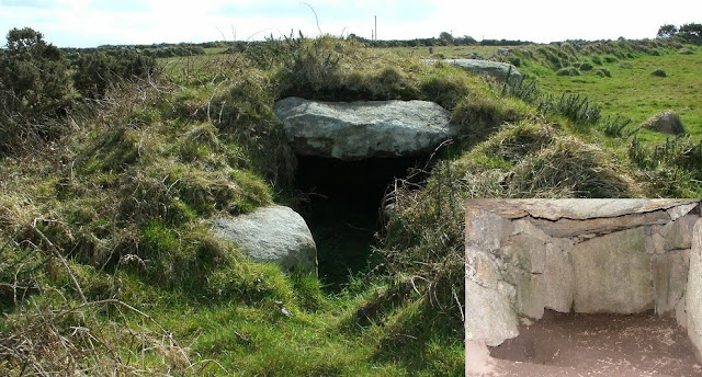
3. Just 1.04 miles (1.67 km) further & the line passes very close (80 ft. [24.6 m.]) to Pennance entrance grave (http://www.megalithics.com/england/pennance/pennmain.htm) which is also known as The Giant's Craw or The Giant's House although not large enough to be a giant's anything, going off local traditional tales concerning giants (tales collected by William Bottrell etc.). This entrance barrow is said to be the best preserved Neolithic entrance grave in Cornwall & seems to be open towards the decimal moon minimum southern rise (120°.)


4. Then 1.30 km (4281 ft.) along we pass very close (8 m/26.2 ft.) to the site of Bosporthennis (pron. boz p'RENNIS, Cornish; house by the way to Ennis) Fogou & possible Courtyard House () discovered in 1934.


Pic.40, Zennor Hill, Penwith

Pic.41, propped stone, Zennor Hill
3. Just 1.04 miles (1.67 km) further & the line passes very close (80 ft. [24.6 m.]) to Pennance entrance grave (http://www.megalithics.com/england/pennance/pennmain.htm) which is also known as The Giant's Craw or The Giant's House although not large enough to be a giant's anything, going off local traditional tales concerning giants (tales collected by William Bottrell etc.). This entrance barrow is said to be the best preserved Neolithic entrance grave in Cornwall & seems to be open towards the decimal moon minimum southern rise (120°.)

Sat. image 11, Pennance entrance grave

Pic.42, & Plan 3, Pennance entrance grave near Zennor
4. Then 1.30 km (4281 ft.) along we pass very close (8 m/26.2 ft.) to the site of Bosporthennis (pron. boz p'RENNIS, Cornish; house by the way to Ennis) Fogou & possible Courtyard House () discovered in 1934.
5. Across the fields just 242 m (740 ft) more & the line passes close (105 ft./32 m) to Bosporthennis Quoit (Neolithic chambered barrow) which is a collapsed quoit that has suffered damage in the past by a local who dressed the capstone circular intending to use it as a millstone until thankfully persuaded to leave it alone. This quoit is unique as it has some of it's covering barrow remaining. - (https://www.megalithic.co.uk/article.php?x=143600&y=036500 )
For a brief description of quoits & courtyard houses see previous post Land's End - The Wash (https://ancientwhisperspenwith.blogspot.com/2019/07/clb-seahenge-pt-2-lands-end-wash.html) or for a more in depth study; http://www.ancientpenwith.org/quoits.html.
 Sat. image 12, Bosporthennis Quoit & iron-age field system
 Pic.43, Bosporthennis Quoit
For a brief description of quoits & courtyard houses see previous post Land's End - The Wash (https://ancientwhisperspenwith.blogspot.com/2019/07/clb-seahenge-pt-2-lands-end-wash.html) or for a more in depth study; http://www.ancientpenwith.org/quoits.html.


6. 430 m (1411 ft.) further & the line bulls-eyes a probable placed stone next to a cleft boulder on Hannibal's Carn (see pic. below), the next carn, just across the valley to the north-east of Carn Galva. It is a little wilder & slightly less accessible than Carn Galva but is/was a Bronze-Age settlement (https://www.megalithic.co.uk/article.php?sid=19913) but also covered in Neolithic stone evidence (see pics. below).

Pic.44, Hannibal's Carn near Bosporthennis

Pic.45, a placed stone next to a cleft boulder, Hannibal's Carn

Pic.46, more placed & propped stones, Hannibal's Carn
7. The seventh site is our featured structure between the two peaks of the south-east tor of Carn Galva.
8. Next, at 1.70 miles (2.74 km) distance to our featured structure, we reach the foot of Chûn (pron. "choon") Hill & the site probable site of a former menhir which gave it's name "Matthew's Longstone"to the field.
9. Then up on the hill the line passes close (67 m/219.8 ft.) to probably the best preserved quoit in Penwith; Chûn Quoit near the remains of Chûn Castle (see satellite & pic. image below) . The Neolithic quoit is small & mushroom shaped with a large overhanging capstone. The stone structure is still intact but no trace of the covering barrow remains.
(A 3D manipulable image by Tom Goskar is available at this link; https://sketchfab.com/3d-models/chun-quoit-cornwall-0d35d1abe91c4ec9ba12de7b31988fcf)
Note that the ancient track-way from Bosullow Trehyllys ancient courtyard house settlement leading up the hill to Chûn Castle runs parallel to our alignment (see satellite image below). For a feature on courtyard houses see previous post; https://ancientwhisperspenwith.blogspot.com/2019/07/clb-seahenge-pt-2-lands-end-wash.html

Sat. image 13, Chûn Castle & Quoit, Morvah, Penwith

Pic.47, Chûn Quoit, the best preserved quoit in Penwith
10. 1.15 km (0.71 miles) further & the line comes within 20 ft. (6.09 meters) south-east of Portheras kerbed roun barrow (https://www.megalithic.co.uk/article.php?x=139100&y=033300) -
11. - before passing through the gap of Carn Kenidjack (just 446 meters (0.27 miles) further (see sat. image & pic. below). This means that if there was a winter solstice in the decimal position (3 degrees different from today's position) witnessed from the Carn Galva structure then the sun would have risen exactly at Lizard Point & set exactly in the gap of Carn Kenidjack.

Pic.48, Carn Kenidjack, Penwith, Cornwall
Sat. image 14, from the Carn Galva structure the decimal winter solstice sunset
alignment passes through the gap of Carn Kenidjack
12. Then another 400 meters (0.24 miles) & it passes through the site of Truthwall Common bronze-age settlement & field system (https://www.megalithic.co.uk/article.php?sid=29501)
1.11 miles (1.79 km) further & the line hits the town of St. Just, coming 187 meters (613.5 ft.) away from the ancient parish church (St. Justin) (a bit too far to be considered on the alignment) with it's inscribed "Selus Stone" & association with St. Justin (Iestin) & his brother St. Levan (Silivan) also coming 110 meters (360.8 ft) from the lovely Plen-an Gwarry (from the Cornish for "field of play") a medieval amphitheater (almost definitely an old Iron-Age round) used in the past for religious "miracle plays" & sports - again a bit far off the alignment. The line however comes very close (14 m/45.9 ft) to the Methodist church. I will have to mention here that from following alignments by satellite image I have noticed them not only pass through or next to many ancient churches but also a lot of relatively modern ones, including Methodist chapels, as well, for instance the St. Michael/Mary alignment passes right through the old Methodist chapel building in Newlin, Penwith among others.

Sat. image 15, the alignment at St. Just in Penwith, Cornwall

Pic.49, Plen-an-Gwarry, St. Just
13. Finally, 1.22 km (0.75 miles) down-line from St, Just our alignment hits the coast at Progo, the site of a now collapsed (in 1998) natural rock arch mentioned earlier.

Pic.50, natural arch at Progo, near St. Just, before &
after it's collapse in 1998
B. 130 deg. - 310 deg.; The dec. winter solstice sunrise - the dec. summer solstice sunset alignment
Bosigran Castle promontory fort - C. Galva structure - Lizard Point

Sat. image 16, Bosigran (310° dec. summer solstice set)- Lizard (130° dec. winter solstice rise)
alignment
This alignment runs from the site of the closest coastal fort to the C. Galva structure - Bosigran Castle, to its most visually obvious landmark - Lizard Point, 22.83 miles (26.75 km) away to the south-east where the land ends & gives way to the sea on the horizon.
There are not many features along this line & most of it runs over sea so a shorter examination beginning at the north-west coastal terminus; Bosigran Castle promontory fort (site) (https://www.megalithic.co.uk/article.php?x=141690&y=036880).

Sat. image 17, Bosigran Castle promontory fort, Bronze-Age settlement & Iron-Age field systems

Pic.51, Bosigran promontory near Carn Galva, Penwith.
The promontory at Bosigran forms part of the stunning rocky cliff coast on the north-east of Penwith that stretches from St. Just to St. Ives. It is the site of an Iron-Age cliff sanctuary but also has Neolithic evidence such as oriented placed stones & a logan stone, it is also famous for being the location for the training of the commandos during the second world war (YouTube video - https://www.youtube.com/watch?v=F11UABufuos)
The alignment starts here then heads south-east over the Bronze & Iron-Age field systems, passing next to the site of a Bronze-Age settlement (https://www.megalithic.co.uk/article.php?sid=48097) & running through our structure at Carn Galva just 1.37 km (0.85 miles) away (see pics & satellite image above).
Then we cross Boskednan Moor, exiting through some cottages at a tiny place called Ding Dong next to the ruins of Ding Dong tin mine, through Boskednan Farm, following Trevaylor Stream ("river" locally) across the slimmest part of Penwith, down to Eastern Green Beach & towards Lizard Point at the extreme south-east end of Mount's Bay 18 miles (28.96 km) across the sea.
As the alignment approaches Lizard Point it bulls-eyes the tiny islet of Rill Ledges as it passes very close to Kynance Cliff, then passes between the rocks of Quadrant before hitting the end of the Lizard's tail that is Vellan Drang promontory.

Sat. image 18, the alignment at Lizard Point

Pic. 52, Lizard Point, Cornwall
C. 300 deg. - 120 deg: The decimal full moon minimum northerly set - the dec. full moon min. southerly rise alignment
Porth Moina Cove - C. Galva structure - St. Michael's Mount

Sat. image 19, the Porth Moina - St.Michael's Mount
decimal full moon minimum alignment
Our third alignment lies from the direction of the decimal full moon minimum set in the north (i.e. the closest full moon set to the equinox sunset in the north) - 300 deg. to the direction of the dec. full moon min. rise in the south (i.e. the closest full moon rise to the equinox sunrise in the south) - 120 deg.
Again no other ancient sites on this alignment although a few cairns & barrows come close & it actually continues through St. Michael's Mount, on through Mount's Bay, skimming the cliffs by Perranuthnoe running across the root of Cudden Point, through Prussia Cove, then across the bay hitting land again at the Lizard & ending up at Kennack Sands near Gwendreath but for time & space reasons we're only going as far as St. Michael's Mount.
Some may think that only having the Mount & the construction on the line discounts it from being an alignment altogether but, as mentioned earlier, one of the apparent functions of the construction (two in fact) is to pinpoint St. Michael;s Mount so, for me this direction is valid.
So, starting at the north-west end, our alignment begins at Porth Moina Cove which isn't an ancient site but is the beach cove adjacent to Bosigran Castle promontory fort from our previous alignment study (B.) also the line runs through a handy spring that rises close to the cliff edge then almost immediately cascades down the cliff leaving little time for the water to become contaminated. In areas of past intensive mining & present farming I would advise extreme caution in drinking from springs, eating shellfish etc. but I have drunk this water & it was delicious.
The line continues across the Bronze & Iron-Age field boundaries, runs through the one of the ruined buildings of Carn Galver Engine House & up the hill to our structure on Carn Galva's south-east tor.
As it runs through the S-E tor, it can be seen that the course of one of the two enclosure walls (enclosure wall 2) seems to run parallel to this alignment (see satellite image below). this means it is also aligned in the direction of St. Michael's Mount which is a decimal full-moon minimum orientation. Evidence of above ground, curvilinear enclosure walls can be found around the north-west tor but the two that enclose the rocky outcrops of the S-E tor (perhaps the first to be built - little remains of them above ground except on the footpaths) are straight & even these may be oriented in significant directions. more weight may be added to this theory later in this post when we examine enclosure wall 1.

Sat. image 20, full moon minimum, north set - min. south rise alignment
with enclosure wall 2 running parallel
As stated before, apart from some near misses of a few cairns & barrows mainly on Boskednan Moor, the line hits no other ancient features until St. Michael's Mount 10.5 km (6.52 miles) away. As shown in the satellite image below the line does not actually hit the mount but runs through the causeway 250 meters (820.2 ft) away, this is however much closer than the St. Michael/Mary alignment comes to it.
Also it can be seen that the line runs through a small, then a large rocky reef known as Little Hogus & Great Hogus (http://www.stauromedusae.co.uk/site_profiles_great_hogus.html). Great Hogus was formed by an ancient volcano, causing the fractures that can be seen in the large chunks of basaltic lava rock that remain today. This site could well have had more significance in the Neolithic era before the inundation of Mount's Bay when the mount was surrounded by trees instead of sea as it's old Cornish name suggests; Karrek Loos yn Coos - the grey rock in the woods.

Sat. image 21, St. Michael's Mount with Little & Great Hogus volcanic reefs

Pic.53, St. Michael's Mount from Great Hogus volcanic reef
D. 60deg. - 240deg.; The decimal full moon minimum northerly rise - the dec. full moon min. southerly set alignment
The Tresibbet Medieval Village (Dozmary Pool) - C. Galva structure - Isles of Scilly alignment

Sat. image 22, the Bodmin Moor - the Isles of Scilly connection
alignment
Right, here goes! - The last two line studies (B.&C.) have been very short with not many features to report, the first, part A. was fairly long but this one's a real biggy, stretching 95 miles (152.88 km) & aligning around 30 sites so I'll try & restrict descriptions to essentials & provide links to other sites for the choice of the interested. I can promise that the remaining two lines (D.&E.) are very short ones. This line also seems to have a very female theme (especially female saints) with one exceptionally very male site.
This alignment is from the decimal full moon northerly minimum rise (i.e. the closest full moon rise to the equinox sunrise in the north) to the full moon dec. southerly min. set (i.e. the closest full moon set to the equinox sunset in the south) & it runs in the same orientation as the St. Michael/Mary alignment. On the Penwith mainland it stretches from St. Ives Head, known locally as The Island (though not an island but a promontory) to Cape Cornwall; not only another promontory but the only cape in Cornwall. But extended the line runs from the Isles of Scilly to Great Yarmouth, Norfolk on the East Anglian coast. We're only going to go as far as where it crosses another major alignment; the Tintagel - Jersey alignment (studied in a previous post; https://ancientwhisperspenwith.blogspot.com/2019/01/the-st-michaelmary-alignment-my.html) at the Medieval Village of Tresibbet (pron.; treZIBbett) near Dozmary Pool on Bodmin Moor.
Starting at the north-west (60 deg.) end:
The Medieval village of Tresibbet (remains) is the crossing point of this current line & another major alignment running from Tintagel Castle to Le Dolmen Du Couperon - a Neolithic/Chalcolithic (Copper-Age) dolmen & passage grave on the Channel Island of Jersey. It from the direction of the summer solstice sunset to the winter solstice sunrise & takes in sites from across Bodmin Moor & North Cornwall (see satellite image below).

Sat. image 23, Scilly - C. Galver structure line (full-moon min) as far as Tresibet Medieval Village (site) - the crossing point on the Tintagel - Jersey alignment (solstice)
1. From Tresibbet Med. Village the alignment runs over the summit of the hill just to the north of Dozmary Pool (http://www.legendofkingarthur.co.uk/cornwall/dozmary.htm - see satellite image below), famous in legend for being the place where King Arthur returned the sword Excalibur to the Lady of the Lake, our first female connection. The pool is not fed by an outside stream but from a spring that rises in it's center.

Sat. image 24, alignment at Tresibbet Medieval village & Dozmary Pool
2. Two miles further & the alignment passes very close to a group of four cairns, a small stone circle & the site of an ancient settlement on Blacktor Downs (https://www.megalithic.co.uk/article.php?sid=46519)

Pic.54, A windswept tree at Blacktor Downs ancient settlement (site)
3. After a mere 1.9 km (0.67 miles), we pass close to the church (St. Catherine), our first female saint) in the small village of Temple (https://en.wikipedia.org/wiki/Temple,_Cornwall) - named so because the land was owned by the mysterious Knights Templar who founded a hospice there in the twelfth century.

Pic.55, St. Catherine, stained glass window
Temple Church, Bodmin Moor
4. Almost immediately after, 619 metres/0.38 miles further it passes through another Medieval village (site) at Medland.
5. 1.20 miles/1.94 km further & the alignment passes through a stone row & hits a rocky outcrop at the summit of Colvannick Tor very close to the site of an ancient settlement & field system.(https://stonerows.wordpress.com/gazetteer/region/bodmin-moor/colvannick-tor/)
Now this is the site that shows the opposite of a female connection as Colvannick is from the Cornish meaning "erect penis" & may have something to do with one of the stones in the stone row, slanting at a suggestive angle. Of course there is every chance that this stone subsided into this position over the years but I think it has a striking resemblance to the center stone of Boscawen-ún stone circle in Penwith (see previous post; https://ancientwhisperspenwith.blogspot.com/2019/03/the-carn-les-boel-seahenge-drombeg.html) which was definitely set at a suggestive angle & oriented towards an outlying menhir. Both stones have straight ridges on their backs (see pic. below).

Pic.56, A. a leaning menhir from Colvannick (Cornish; "erect penis") Tor stone row, Bodmin Moor, very similar to B.& C.; the central stone at Boscawen-ún stone circle in Penwith
6. 1.82 miles (2.93 km) further up the A30 road we come within 179 meters to a round barrow known as Council Barrow (https://www.themodernantiquarian.com/site/5743/council_barrow.html) which, because of the unfortunate close proximity to this major road, has apparently become strewn with fly tipping refuse.
7. 4.53 miles (7.30 km) down-line & we come to Nanstallon village where our line passes through the small church/chapel (St. Stephen) & runs close to one of only a handful of Roman forts in Cornwall (https://www.pastscape.org.uk/hob.aspx?hob_id=431370)
8. 6.20 miles further the alignment nestles nice & closely to the impressive earthworks of Castle-an-Dinas Iron-Age hill-fort in the parish & near the town of St. Columb Major (named after their female patron saint Columba who was martyred in the area). It is the biggest of the Cornish hillforts & has a rich history (http://www.cornwallheritagetrust.org/our-sites/castle-an-dinas/)

Sat. image 25, the alignment at Castle-an-Dinas, St Columb Major

Pic.57, The large & impressive earthworks of Castle-an-Dinas, St Columb Major
9. 1.44 miles (2.32 km) down-line from Castle-an-Dinas we pass the hamlet of Quoit, named after a large & impressive dolmen known as The Devil's Quoit, destroyed in 1870 (the paranoia in the naming may give a clue to what kind of people destroyed it). What is believed to be the capstone was later unearthed (see pic. below & - https://www.megalithic.co.uk/article.php?sid=12509).

Pic.58, The Devil's Quoit capstone & reconstruction drawing (inset)
10. Just 1.20 miles (1.93 km) across the fields & the alignment runs through the crossroads of two consecutive hamlets, 1.25 miles (2.01 km) apart, the first called Black Cross, the second called White Cross. There are no ancient inferences to these features but I like the "coincidental" harmony of opposites aspect & the fact that these two hamlets are aligned in a 60 degree full-moon minimum orientation, just like features on the St. Michael/Mary alignment.

Sat. image 26, alignment at Black Cross & White Cross
11. Earlier in this post I mentioned how relatively modern places of worship, including Methodist chapels, cropped up on alignments as well as ancient features & older churches & here's a prime example: The Preaching Pit at St. Newlyn East was constructed in 1852 on the site of an old stone quarry. It was used for open air preaching by the Methodists & it has an edge alignment with our line (see satellite image below). ( https://historicengland.org.uk/listing/the-list/list-entry/1141454 )

Sat. image 27, & pic 59, St. Newlyn East preaching Pit - a relatively modern feature (1852) aligned
& in use in 1912
12. 2.90 miles (4.67 km) later & the line passes close-ish (380 metres/0.23 miles) to the well preserved Perran (or St. Piran's) Round near Perranporth. For info on this site & on Perran (St. Piran) see previous post; https://ancientwhisperspenwith.blogspot.com/2019/03/the-carn-les-boel-seahenge-drombeg.html.

Pic. 60, Perran (or St. Piran's) Round near Perranporth
13. 4.26 miles (6.85 km) further & we come to the town of St. Agnes named after their patron Roman Saint Agnes - another female martyred saint. The line runs next to the Catholic Church of Our Lady, Star of the Sea (another female dedication) which is a very modern church building having been built in 1958.
1 km (0.62 miles) from this point & our alignment runs across St. Agnes Beacon (https://www.megalithic.co.uk/article.php?sid=33317 ) a coastal beacon hill with spectacular panoramic views over sea & inland including Carn Brea, St. Ives Bay, Porthtowan & Bodmin Moor. It is known as a barrow cemetry having four cairns along it's crest, our alignment passes between these cairns.
Pic. 61, St. Agnes Beacon
1.4 km (0.86 miles) further & our alignment hits the coast at Chapel Porth near the site of the old chapel & very close to yet another natural arch.

Pic.62, Chapel Porth beach near St. Agnes
14. Then we head out to sea, down coast for 8.36 miles (13.46 km) until we come to Godrevy Island & lighthouse at the tip of Godrevy Head which is the site of a Neolithic headland settlement (https://en.wikipedia.org/wiki/Godrevy) with a round barrow & nearby multi-age settlement with evidence dating from the Mesolithic (from 11600 - 6000 years ago in UK) to the Medieval eras; https://www.heritagegateway.org.uk/Gateway/Results_Single.aspx?uid=MCO28590&resourceID=1020 . This point marks our entry into Penwith.

Sat. image 28, alignment from St. Agnes Beacon
Any readers of previous posts will know that alignments have a habit of picking out islands, no matter how small &, as can be seen in the satellite image below, this line pretty much bulls-eyes the lighthouse island. Also like many features on alignments the island itself looks oriented in the same direction.
For a modern female connection, Godrevy Lighthouse is the inspiration for the book "To The Lighthouse" by Virginia Woolfe.

Sat. image 29 & pic.63, alignment at Godrevy Island & Lighthouse
15. From one shoulder of St. Ives Bay to the other as our alignment runs 3.77 miles (6.07 km) across it's mouth & enters land at St. Ives Head (known locally as "The Island" although it is a promontory). Its old names Pendinas (from Cornish = fort headland), Dinas Ia (Cornish; St. Ia's fort) etc. suggest it was an ancient cliff castle.
St. Ives is named after their patron St. Ia (or Ya, Ayr, Hya, Ithe, Eye etc. (another martyred female saint), said to have been an Irish princess who sailed into St. Ives Bay on a giant leaf (probably an Irish leather boat). The parish church (St. Ia) is said to be built over her grave.
The alignment runs in between St. Ia's Head & St. Ia's church, close to a rocky outcrop called Carn Crows (Cornish; the crag with the cross) because of an ancient cross, no longer there, that was mounted on the carn.
Another modern female connection here is that the line goes through the building of the Barbara Hepworth Museum & right down the Sculpture Garden. It continues running very close & parallel to Ayr Lane & through the area named Ayr - that name being one of the versions of Ia or St. Ives

Sat. image 30, The alignment at St. Ives, Penwith

Pic. 64, St. Ives harbour front with St. Ives Head (or "The Island") & St. Ia's Church next to the short pier
(Photo. by John Such)

Pic.65, St. Ia (Ives) of Cornwall
16. At the back of the upper end of St. Ives stands Rosewall Hill with it's enigmatic rock formations on it's two carns (see pic. below), ruined mine chimneys & spectacular panoramic views. The alignment runs straight up the back of the hill, between the carns & next to a Bronze-Age cairn near it's summit (https://www.heritagegateway.org.uk/Gateway/Results_Single.aspx?uid=MCO3427&resourceID=1020).

Sat. image 31, The alignemnt at Rosewall hill near St. Ives

Pic.66, Rock formations & views on the carns of Rosewall Hill near St. Ives
Just 800 metres across the valley from Rosewall Hill the alignment climbs to the summit of it's close neighbour Trendrine Hill (pron. tren-DRYn - dry as in not wet.) & as it runs across the peaks & carns of the high ground towards Zennor Hill, it encounters four significant ancient features within a mile (0.78 miles/1.27 km):

Sat image 32, alignment in Zennor parish, Penwith
17. First, three cairns at the carn atop Trendrine Hill, quite large but in different states of preservation, at least one with kerbstones & a cist (https://www.megalithic.co.uk/article.php?x=147900&y=038700).

Pic.67, Cairns & rock formations, Trendrine Hill near Zennor
18. Just 260 metres (853 ft) away we pass the rocky outcrop Carn Boscubben under which there is a prehistoric well.
19. Then, just another 335 metres (1099 ft.) the line bulls-eyes the site of a late Bronze/early Iron-Age settlement near a rocky carn on Sperris Croft (the old name was Croft Speris from the Cornish; croft = rough grazing enclosure & sperys = (with the) spirit or ghost). There are remains of a field system & a line of overgrown roundhouses, through one of which our line passes: (https://www.themodernantiquarian.com/site.php/11704/sperris_croft.html).
20. A mere 250 metres (820.2 ft) down-line & we pass 40 metres (131.23 ft.) to the south-east of the first of two Neolithic dolmens within 313 metres (1026.9) of each other; Sperris Quoit (see pic. below). There isn't a lot left of this construction & the area it covers isn't very large but it was recorded as a portal dolmen by the local archaeologist William Borlase in 1769 when the remains must have obviously been more substantial. It was rediscovered in 1954 (http://www.megalithics.com/england/sperris/spermain.htm).

Pic.68, What's left of Sperris Quoit near Zennor Hill
21. The remains of the second dolmen; Zennor Quoit are more substantial (see pic. below) with it's toppled large, flat granite capstone & the stumps of several uprights. The capstone was intact at least in the time of the aforementioned archaeologist William Borlase (mid-late 18th century) as the drawing taken from his study shows (in pic. below). The nearby village of Zennor takes it's name from their patron St. Sinara - another female saint. (http://www.megalithics.com/england/zennor/zennmain.htm & https://en.wikipedia.org/wiki/Zennor_Quoit)
In it's time Zennor Quoit would have probably been covered within a mound except for the flat capstone & would have been visible from the Carn Galva structure. Perhaps Sperris Quoit would have too depending on how big it was. The fact that our line travels between the thin gap that these two quoits leave at this angle means that they would have provided a good sighting indicator for this orientation on the horizon.

Pic.69, Zennor Quoit with it's toppled capstone & as recorded intact
22. Our alignment then swoops down the steep south-west side of Zennor Hill, over the ancient field systems & 1.6 km (0.99 miles) further on hits Trewey Hill where it passes between, to the south; the remains of a Neolithic chambered cairn (https://www.heritagegateway.org.uk/Gateway/Results_Single.aspx?uid=MCO28323&resourceID=1020) & a destroyed round barrow - & to the north; a kerbed cairn known as Gundry Cae (https://www.megalithic.co.uk/article.php?sid=19920 & https://www.heritagegateway.org.uk/Gateway/Results_Single.aspx?uid=MCO2754&resourceID=1020) before running against the site of a Bronze-Age round barrow now ploughed into a field (see satellite image below -- https://www.heritagegateway.org.uk/Gateway/Results_Single.aspx?uid=MCO3858&resourceID=1020)

Sat. image 33, The alignment on Trewey Hill near Zennor
23. 700 metres (0.43 miles) on & we pass a menhir next to two Bronze-Age hut circles at Kerrowe. Excavations in 1935 revealed two Bronze-Age urns beneath the stone:(https://www.megalithic.co.uk/article.php?sid=6069)

Sat. image 34, alignment at Kerrowe
24. 600 metres (0.37 miles) on & the line runs through an Iron-Age/Romano courtyard house settlement & round at Chykembro (pron. tchy-KEM-bro; from the Cornish for; house (of the) Welshman). (https://www.heritagegateway.org.uk/Gateway/Results_Single.aspx?uid=MCO10439&resourceID=1020 & https://www.heritagegateway.org.uk/Gateway/Results_Single.aspx?uid=MCO10440&resourceID=1020)
25. 1.11 km (0.68 miles) further & the alignment runs up a slender track-way among the walls of the Iron-Age field systems of Bosporthennis (pron. boss-p'REN-iss; from the Cornish for; dwelling by the approach to Ennis) & runs along the site of an Iron-Age round. as the walled track-way is oriented in the same direction as the line, perhaps it is the original approach (see satellite image below). For a short piece on Cornish Rounds see previous post; - https://ancientwhisperspenwith.blogspot.com/2019/03/the-carn-les-boel-seahenge-drombeg.html

Sat. image 35, The site of a round amid the iron-age field boundaries at Bosporthennis
& perhaps the original approach trackway following the alignment
26. Literally just over the fence of the field & we bulls-eye the site of a Bronze-Age settlement lying to the east of Hannibal's Carn mentioned earlier (https://www.megalithic.co.uk/article.php?sid=19913).
27. The 27th site along this alignment is our featured Carn Galver structure. - Not many to go now, I promise!
Then the alignment cuts across the neighbouring hill to Carn Galva; Watch Croft & close-ish to the menhir & tumuli near the summit that marks the high point of Penwith. It passes 80 metres away from a carn known as White Downs or Watch Croft Cairn (https://www.heritagegateway.org.uk/Gateway/Results_Single.aspx?uid=MCO4647&resourceID=1020).
28. Just 500 metres (0.31 miles) on & we pass through the site of an ancient settlement & next to a probable Iron-Age round at Trevean (see satellite image below -- https://www.themodernantiquarian.com/site.php/11709/trevean_round.html).

Sat. image 36, alignment at Trevean
29. After such a tight concentration of sites on our alignment we need to travel over a whole two miles (3.21 km) to get to the next; Carn Eanes is a prominent hill near the village of Pendeen & the line passes a menhir on it's heights that was re-erected in 1985 after being discovered by the Blacksmith & Dowser Hamish Miller of Trencrom, Penwith (see satellite image below).

Sat. image 37, the re-erected menhir at Carn Eanes near Pendeen
30. 1.70 miles further & we near the coast entering the beautiful Kenidjack Valley, this is a different place to the aforementioned Carn Kenidjack (although if you follow the course of the valley inland it does lead to The Gump over which Carn Kenidjack stands) but as the name is derived from the Cornish for "fuel (gorse)gathering place" it would apply to multiple locations.
The valley runs at the foot of Kenidjack Cliff Castle which is/was an Iron-Age promontory fort but has Bronze-Age features nearby & even has been suggested to have been the site of Neolithic stone-axe manufacture. It also has a placed stone oriented to the northernmost extreme of the Isles of Scilly, visible on the sea's horizon, which may be Neolithic; (https://www.heritagegateway.org.uk/Gateway/Results_Single.aspx?uid=MCO6552&resourceID=1020 ... &... https://historicengland.org.uk/listing/the-list/list-entry/1004388).
The line passes at the foot of the castle and runs into the sea, clipping the rocky lip at the northern foot of Cape Cornwall. A cape is a promontory where two bodies of water meet & this is the only one in Cornwall (see satellite image below). It's old Cornish name was Kilgoodh Ust meaning "goose-back (referring to it's shape) of St. Just (the patron & name-sake of the nearby town)"
There are no remaining traces of ancient features at this site but it has suffered from centuries of intense mining activity & to suggest such a prominent & advantageous head-land was overlooked in prehistory is, in my opinion, almost risible. The eighteenth century local archaeologist William Bottrel recorded traces of Iron-Age castle defences, probable Bronze-Age pottery finds & an empty cist in a ruined barrow (https://www.themodernantiquarian.com/site.php/14029/cape_cornwall.html)

Sat. image 38, Kenidjack Valley & Cliff Castle, Cape Cornwall & (inset) St. Helen's Oratory with Kenidjack Cliff Castle in background

Pic.70, The ramparts of Kenidjack Cliff Castle near St. Just, Penwith
St. Helen's Oratory, Cape Cornwall
In keeping with the female saint's theme of this alignment, as it clips Cape Cornwall, it runs close (200 metres/656.16 ft.) to St. Helen's Oratory (see pic. below) - a ruined but very pretty early Christian chapel building that is said to date back to the Romano-Britain era. There is also the remains of an enclosed dwelling on the site. (http://www.saintsandstones.net/saints-sthelensoratory-journey.htm & - https://historicengland.org.uk/listing/the-list/list-entry/1004512)

Pic.71, Cape Cornwall from Kenidjack Cliff Castle & St. Helen's Oratory
The Isles of Scilly
31. Hitting the coast is not quite the end of the journey for this alignment as 27 miles (43.45 km) across the sea from Cape Cornwall we encounter the stunningly beautiful Isles of Scilly archipelago. A lot could be written about this amazing place with it's vast number of ancient sites etc. but in a feature of this length I will leave it to others in provided links. Suffice to say that, also in keeping with the female saints theme, our alignment hits the only islands truly named after female saints; the isles of St. Mary's & St. Agnes (there is also a small isle called St. Helen's but this name is a corruption of St. Elidius - a male saint) (see satellite image below).

Sat. image 39, The alignment in the Isles of Scilly hitting the two
Islands named after female saints; St. Mary's & St. Agnes

Pic.72, The isles of St. Mary's & St. Agnes of the Scilly archipelago
E. 320 deg. - 140 deg: The decimal full-moon maximum northerly set - the dec. full-moon max. southerly rise
Carn Veslan - C. Galva structure - Gear Rock

Sat. image 40, 320° - 140° moon max. alignment
As Carn Galva is close to the coast the three north-west terminations of the alignments are very close together; the 300 degree line hits Porthmoina, the cliffy cove & small beach below Bosigran Cliff Castle, the 310 deg. runs through the castle itself & this one, the 320 hit's Carn Veslan which is the next promontory or headland to Bosigran Castle.

Sat. image 41, the north-west end of the alignments cross
No ancient features to report at Carn Veslan Head but I can't imagine it not being used by the people of the Bosigran settlement. The alignment comes ashore over the headland, over the slightly set back carn, over the Bronze & Iron-Age field boundaries, along the western side of the north-west tor & joining saddle & as it runs through our construction on the S-E tor it can be seen that, just like enclosure wall 2 running parallel to the Porthmoina - St. Michael's Mount dec. full-moon minimum alignment back in part C., it looks like enclosure wall 1. (of which also not a lot remains above ground) runs parallel to this one which is the dec. full-moon maximum orientation. Not only that but, as shown in the satellite images below, if you follow the direction of enclosure wall 1 to the south-east you will run along the edge of a large kerbed cairn (erroneously marked as "Four Parishes Rock" on Google satellite, which actually is slightly to the north-west of the cairn at the crossing of the footpaths; https://www.megalithic.co.uk/article.php?sid=24022 & https://www.heritagegateway.org.uk/Gateway/Results_Single.aspx?uid=MCO2183&resourceID=1020 ) and after exactly 1 kilometer (0.62 miles) from C. Galva you will end up slap bang in the middle of Boskednan stone circle (https://en.wikipedia.org/wiki/Boskednan_stone_circle & https://www.megalithic.co.uk/article.php?x=143500&y=035100).

Sat. image 42, enclosure wall 1 aligned to the full moon maximum orientation
(Click on image to enlarge)
(Click on image to enlarge)

Sat. image 43, The course of enclosure wall one runs parallel with the alignment, is edge-aligned with Boskednan kerbed cairn & centrally aligned with Nine Maidens stone circle

Pic.73, Boskednan or Nine Maidens stone circle with Carn Galva south-east tor in the distance - exactly 1 kilometer away
Back to our alignment at the C. Galva structure. After 370 metres (0.22 miles) the alignment passes trough a group of four - six stony cairns running right through the northernmost (https://www.megalithic.co.uk/article.php?sid=48122). About 460 metres (0.28 miles) further & it passes 35 metres (114.82 ft.) away from the aforementioned large Boskednan kerbed cairn that is edge aligned with enclosure wall 1. (site). Then 730 ft. further & we run even closer (40 ft/ 12.19 m) to the Neolithic Boskednan or Nine Maidens stone circle.
After leaving Boskednan Moor there are no more close ancient features for a while, the alignment follows Chyandour (pron. tchy-an-DOWER - Cornish; house by water) stream (or "river" locally) across the neck of Penwith, passing through the village of Heamoor & then into Penzance (Cornish; holy head[land] or promontory) where it cuts through Penzance Cemetery near the outskirts. Here the line bulls-eyes the site of a suspected Cornish Iron-Age round referred to as Heamoor Round (https://www.heritagegateway.org.uk/Gateway/Results_Single.aspx?uid=MCO8025&resourceID=1020).
This site is tightly aligned as our line comes right through the middle of Penzance Cemetery & there seems to be a bit of a cemetery theme to this alignment as, when it passes through Penzance town, it comes close to the original site of the Penzance Market Cross - a 7ft. Medieval inscribed cross, over 1000 years old, that now stands in Penlee Park outside the museum after in it's later life being moved around the town, to central Greenmarket , Morrab gardens etc. In fact the terrible damage to the middle of one side was said to have been done by chipping away at it to make it fit in a recess when it was moved to the Market House (see image below).
Before Penzance town existed this cross was said to have stood in a cemetery field by what is now a furniture shop near the top of Morrab Road. It has many fascinating inscriptions, one urging passers by to pray for the dead. There has been different opinions as to what the inscriptions mean but an excellent book has been published ("Penzance Market Cross" by Thomas Charles) where he deciphers the codes & numerology in the inscriptions to reveal when this cross was made, who commissioned it & who paid for it among other things. He also casts doubt on the fact that some have declared that it is dedicated to an old Cornish king Ricatus.
A 3d image of the cross can be seen & manipulated at this link (maximise to full screen for best viewing); https://sketchfab.com/3d-models/penzance-market-cross-untextured-6760debf8f17424c8f20579b910f4c2e - By Tom Goskar.

Sat. image 44, The alignment at Gear Rock & Penzance (the Holy Headland)

Pic. 74, The Penzance Market Cross in some of it's different later locations
The line then runs against St. Mary's church (Mary the Virgin), (cemetery side, not church building side, keeping with the theme) The present building dating from 1835 although it stands on the grounds of a previous chapel (of Our Lady). that was first recorded in the fourteenth century.
As can be seen in the satellite image above, the alignment then continues down the headland that is the origin & namesake of the town; Pen Sans, the Holy Headland, said to be named after a small chapel (St. Anthony - patron saint of fishermen) that stood there as probably the first stone building of Penzance. A small cluster of rude wooden huts were said to surround it inhabited by tough people who used the headland as a natural jetty for their fishing - the first Penzancers (https://savetheholyheadland.blogspot.com/2013/01/history-of-stanthonys-chapel-penzance.html).
Perhaps their are other reasons why this headland is sacred as the St. Michael/Mary alignment also passes very close (see satellite image below) - even across it if you consider that more of it would be above sea before the inundation of Mount's Bay. See previous post; https://ancientwhisperspenwith.blogspot.com/2019/01/the-st-michaelmary-alignment-my.html
In between Battery Rocks & Gear Rock the alignment crosses the St. Michael/Mary alignment as it cuts across at just under 60° just at the tip of the Holy Headland (see satellite image below).

Sat. Image 45, the St. Michael/Mary alignment at the Holy Headland of Penzance
Also apparent (in the satellite image above) is the fact that Gear Rock was probably the end carn (or tor) to this promontory & our line bulls-eyes it.
The word "Gear" in the name comes from "caer" which is Cornish for fort or enclosure & perhaps it was a promontory fort before this long headland succumbed to the rising tides. In fact this was probably the case as Gear Rock has been identified as being another site, as well as Kenidjack Cliff Castle, as the source for Greenstone for axe manufacture in the Neolithic period (https://www.heritagegateway.org.uk/Gateway/Results_Single.aspx?uid=MCO25098&resourceID=1020). Even so it's hard to imagine that a promontory stretching almost half a mile (804.67 m) among or above what would have been the forest of Mount's Bay would not have served some use in those times.
Today all that can be seen is a stub of rock with a warning beacon (see pic. below).

Pic.75, All that can be seen of Gear Rock today
F. 40° - 220°: The decimal full-moon maximum northerly rise - the dec. full-moon max. southerly set alignment
Carn Naun cliff sanctuary - C. Galva structure - Longships Rocks & Lighthouse

Sat. image 46, the 40° - 220° moon max. alignment
This is the last alignment of the solar/lunar limits cross & it is from the decimal maximum full-moon rise in the north (i.e. the closest full-moon rise to north [360°/0°]) to the dec. max. full moon set in the south (i.e. the closest full-moon set in the south [180°])
We start at Carn Naun which is an unrecorded but probable cliff sanctuary (http://www.ancientpenwith.org/cliffcastles.html#Trip)

Sat. image 47, alignment at Carn Naun cliff sanctuary
Two miles south-west & it passes close (50 m./164 ft.) to the Giant's Rock, a logan (loggan) stone just outside Zennor. This rocking stone is another that requires more effort now than in the past & as is common with logan stones, was associated with witches. (https://www.themodernantiquarian.com/site.php/2563/giants_rock.html)

Pic. 76, the Giant's Rock at Zennor
After 1.3 miles (2.09 km) our line passes very neatly between a damaged round barrow & one of two (Bronze-Age) Scillonian style chambered cairns near a courtyard house settlement (Iron-Age/Romano era) at Treenhttps://www.heritagegateway.org.uk/Gateway/Results_Single.aspx?uid=MCO27511&resourceID=1020, https://www.heritagegateway.org.uk/Gateway/Results_Single.aspx?uid=MCO10487&resourceID=1020 .
A Scillonian style chambered cairn (or entrance grave) is a small round cairn with a narrow entrance leading to a rectangular stone box chamber. The cairns would have been there much longer than the courtyard houses although they were probably built on earlier structures.

Sat. image 48, the alignment at Treen settlement & cairns

Pic. 77, a Scillonian style chambered cairn at Treen
1.5 kilometers down-line & we run through our featured construction at Carn Galva, 1 km (0.62 miles) further & we run very close to a cairn & we run very close to a cairn at Dakota (https://www.heritagegateway.org.uk/Gateway/Results_Single.aspx?uid=MCO4618&resourceID=1020), on the neighbouring hill of Watch Croft.
Another 1.50 km/ 0.93 miles and we pass next to another courtyard house settlement at Bosullow-Trehyllys (pron. BOZ-low t'RILL-eez) near Chûn Castle. On the other side of Chûn Hill the line hits another chambered cairn at Boslow Farm.
3.2 km/1.98 miles further & we pass through the small settlement of Kelynack (pron. ke-LY-nack) where the alignment passes close to a menhir, then a roadside well before bulls-eyeing Kelynack Round (see satellite image below) https://www.heritagegateway.org.uk/Gateway/Results_Single.aspx?uid=MCO51080&resourceID=1020 .

Sat. image 49, the alignment at Kelynack
Then we run across an Iron-Age field system past Nanquidno & hit the coast at Nanjulian Carn. The alignment then heads across Sennen Cove & hits the cluster of rocks (with a lighthouse) off Land's End known as Longships (see satellite image & pic. below).
The seascape around Land's End is famously treacherous to the seafarer, with large merging currents, submerged rocks & reefs. (https://www.cornwalls.co.uk/cornwall/longships_lighthouse.htm)

Sat. image 50, alignment at Land's End & Longships Rocks

Pic.78, Longships Rocks & Lighthouse, Land's End, Penwith
And that's the final solar/lunar limit cross alignment finished. I could add that the decimal Equinox sun -rise direction (due East) from the C. Galva construction runs along the valley at the foot of Trencrom Hill - the only so far unaccounted for neolithic tor enclosure in Penwith, finally ending up at the mouth of the Fal Estuary, the major river inlet of Cornwall.
The 10 degree tilt axis
Just one more thing,...... In previous posts & studies I have noticed another orientation that has been strongly apparent on at least two significant ancient features; the 10 degree axis noticeable at the Hurlers stone circles & at Avebury Henge.
In previous post Avebury Geometry pt. 2. (https://ancientwhisperspenwith.blogspot.com/2018/11/avebury-geometry-pt-2-a.html)
A hexagram depicted in a nearby "crop circle" helped me decode information from the workings of Avebury Henge & the positioning of some of the surrounding features (see pic. below).

Pic. 79, The hexagonal/hexagram crop "circle" of 2005 pointing to the practical centre of Avebury Henge
(Photo. by Steve Alexander)
A hexagram with a spur pointing north will display north & south, east & west (decimal equinox sunrise & set) & a 60 degree cross which indicates the dec. full moon minimum rises & sets.
If you tilt the hexagram from 0° to 10° you will see that the north-west & south-east spurs will be indicating the 310° decimal summer solstice set - 130° dec. winter solstice rise axis (see plan below).
The crossed edge alignments of the inner stone circles at Avebury Henge provide two positions that allow for these two positions. At a ten degree tilt the hexagram indicates the earthworks & barrows on nearby Windmill Hill & the bottom spur indicates the nearby man made mound Silbury Hill which is on the 10° axis (see plans below).
Plan 4, Crossed edge alignments of the inner circles at Avebury; equinox & full-moon max.practical centre at crossing point

Plan 5, hexagram lined up with equinox edge alignment, displaying north,south,
& decimal equin. rise & set & full-moon minimums

Plan 6, hexagram lined up with full moon max. edge alignment, displaying a solstice line leading to Windmill Hill, the Cove & Obelisk central features alignment & 10° tilt axis leading to Silbury Hill
As discussed previously in this post, because of the curvature of the earth, the orientations of alignments vary slightly as they go along. It depends on their direction how much they vary but for example the St. Michael/Mary alignment is a 60° line & gains about one degree every sixty miles in that direction. At Carn Lês Boel, the south west terminus it's 59° but interestingly the line is exactly 60° when it passes between the top two stone circles at The Hurlers.
That means if you point a hexagram north on this spot at The Hurlers, it will indicate the St. Michael/Mary alignment. The three stone circles of The Hurlers are all on a 10° axis & if you align your hexagram at this 10° tilt the opposite spurs will indicate the Tintagel - Jersey alignment which is a 310° (dec. summer solstice set) - 130° (dec. winter solst. rise) line (see plans below).

Plan 7, upright hexagram marking the St. Michael/Mary alignment
which is exactly 60° (f-moon min.) at The Hurlers stone circles, Bodmin Moor, Cornwall

Plan 8, hexagram at 10° tilt marking The Hurlers axis &
the Tintagel - Jersey alignment (solstice)
So I decided to see if the Carn Galva structure had a ten degree alignment of it's own - what a surprise! so far the solar/lunar limit cross has been connecting, not only significant ancient sites but significant ancient sites on prominent natural features, the 10° axis connects the most iconic promontory fort on the north coast; Gurnard's Head with the most iconic promontory fort on the south coast; the aforementioned Treryn Dinas, where you will find the Logan Rock (see satellite images & pics below).

Sat. image 51, solstice cross & 10° tilt axis from the Carn Galva structure

Sat. image 52, 10° alignment at Gurnard's Head promontory fort & Chapel Jane
Gurnard's Head promontory is named so because of it's resemblance to the Gurnard - a fish caught by local fishermen. In history it was known as Ynyal from the Cornish for "desolate" & in the 1800's it became known as Trereen Dinas probably with confusion or association with the Logan Rock promontory fort at the other end of this alignment known as Treryn Dinas - both names mean "fort at Treen" & both are proximal to different hamlets called Treen from the Cornish meaning "farm on the slope".
There are remains of an iron-age fort but, again, to think that this most advantageous feature would have been overlooked in the preceding eras is highly unlikely as it is the most protruding headland on the north coast of Penwith. (https://www.cornwalls.co.uk/history/sites/gurnards_head.htm ... https://en.wikipedia.org/wiki/Gurnard%27s_Head & https://historicengland.org.uk/listing/the-list/list-entry/1004300)
As can be seen in the satellite image above, the alignment doesn't run down the spine of the headland but hits a small cove on the north-east shoulder, near the ruins of a cliff-top hermits oratory dating from the first century known as Chapel Jane - probably not the name of a saint but from the Cornish word "yeyn" meaning cold.

Pic.80, Gurnard's Head promontory fort near Zennor, Penwith
The line then bulls-eyes a historic well at nearby Porthmeor before running through the Carn Galva structure, then after passes close to nearby Mên Scryfa (https://en.wikipedia.org/wiki/M%C3%AAn_Scryfa) & Mên-an-Tol, mentioned earlier (https://www.heritagegateway.org.uk/Gateway/Results_Single.aspx?uid=MCO27455&resourceID=1020), even closer to West Lanyon Quoit (http://www.megalithics.com/england/wlanyon/wlanmain.htm), passing over the top of Sancreed Beacon (https://en.wikipedia.org/wiki/Sancreed_Beacon), then bulls-eying a bronze-age cairn (https://www.heritagegateway.org.uk/Gateway/Results_Single.aspx?uid=MCO4176&resourceID=1020) near Creeg Tol - the carn or natural rocky outcrop close to Boscawen-Un stone circle, before reaching Treryn Dinas promontory fort on the south coast near Porthcurno (see satellite image & pics below).

Sat. image 53, 10° alignment at Treryn Dinas promontory fort
& the Logan Rock.
Treryn Dinas promontory (mentioned earlier in this post), just like Gurnard's Head on the north coast, is the most protruding & stunningly beautiful headland on the south coast of Penwith.
It also has remains of an Iron-Age cliff castle, also two nearby Iron-Age rounds, but was also probably used in earlier eras, in fact a friend of mine actually found a bronze brooch pin at this site that was confirmed to be Bronze-Age.
This site has enjoyed much history & for centuries has been regarded as a "must see" tourist spot. Also it has it's legends concerning giants & (probably due to the Logan Rock) witches.
(https://www.megalithic.co.uk/article.php?sid=10633 ... https://en.wikipedia.org/wiki/Logan_Rock ... & https://www.heritagegateway.org.uk/Gateway/Results_Single.aspx?uid=MCO6583&resourceID=1020)

Pic.81, Treryn Dinas (Logan Rock) promontory fort from Pedn-an-Vounder beach near Porthcurno, Penwith
Sort of Summary
The structure on the S-E tor of Carn Galva seems to pinpoint many significant natural features, used in ancient times such as other Neolithic tor enclosures, in fact more distant tor enclosures are also visible from here, e.g. Carn Brea (15 miles/24.14 km away) near Camborne, Rough Tor & Brown Willy (50 miles/80.46 km away) on Bodmin Moor.
Many local significant natural/ancient features seem to be aligned by decimal or general solar/lunar limit orientations that we have seen at ancient sites in other areas (see previous posts). In fact if these evenly spaced, geometric directions were implanted in the mind, one would have an entire picture of the distant unseen landscape 9& features) around. As the alignments pinpoint river mouths, islands, hilltops, springs, settlements, monuments etc. they would make the perfect routes for cyclic or exploratory travel (even in space as they are based on the movement of celestial bodies).
It is not ridiculous to me to suggest that these dimensions could exist in us naturally as there is a geometric influence on everything organic (leaves, flowers, fruit, seed patterns etc.) & even inorganic (e.g. crystals, snowflakes, molecules etc.). With a constant awareness of these geometric orientations you would have a much better Idea of your position within the landscape & so be more connected with it.